
User`s manual
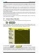
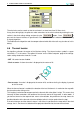
Table Of Contents
- Introduction
- User Interface
- Display Elements
- Cross Country Tasks
- Glide Computer
- Atmosphere and Instruments
- Airspace, Traffic and Team Flying
- Avionics and Airframe
- Quickstart
- InfoBox Reference
- Configuration
- Data Files
- About XCSoar
- GNU General Public License

6 ATMOSPHERE AND INSTRUMENTS
6.2 Air data inputs
Where additional aircraft dynamics or air mass data are provided by an intelligent variometer, XC-
Soar can often make use of it or display it in a separate InfoBox. Key sensor measurements that
XCSoar uses include:
• Gross total energy variometer (rate of change of the total energy of the aircraft) Used for dis-
play, and for calculation of netto variometer.
• Netto variometer (estimated vertical velocity of the air mass at the aircraft) Used to display, and
to colour the trail so that it may effectively show areas of lift and sink.
• Aircraft acceleration (load factor) Used for netto variometer calculations where an external
netto variometer is not provided.
• Barometric altitude Used for display
• Indicated airspeed Used for display, in compensating final glide calculations for aircraft kinetic
energy, and in netto variometer calculation where an external netto variometer is not pro-
vided.
• Air density Used for calculating true airspeed from indicated airspeed.
6.3 Wind display
A continuous display of wind strength and direction is provided on the map. The wind information
is derived from the gliders wind drift during thermal flight (climb mode).
The wind direction and speed are displayed as a wind vector on the moving map display and
optionally in numeric form in the data display fields. The length of the vector indicates the wind
magnitude, and this magnitude is also displayed near the wind vector.
The wind data is one of many data sources used to calculate final glide information. It is possible
to manually adjust the wind used in all calculations. For more details, see 6.5.
6.4 Wind estimation
XCSoar offers two ways of estimating wind during flight.
• Circling This method uses GPS position fixes to estimate the wind based on drift, typically while
thermalling; and is available on all XCSoar installations.
• ZigZag This method uses GPS position fixes and true airspeed measurements to estimate the
wind, typically during cruise. It is only available where XCSoar is connected to an intelligent
variometer that outputs true airspeed.
The wind magnitude and direction can also be adjusted manually from Wind Settings (see
below).
Statistics are gathered so that winds are recorded at different heights and times. When the glider’s
altitude changes significantly, the statistics are consulted to determine the best estimate of the wind
based on previous measurements.
59 XCSoar Manual (Altair version) • XCSoar-A-EN