
User`s manual

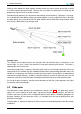

Table Of Contents
- Introduction
- User Interface
- Display Elements
- Cross Country Tasks
- Glide Computer
- Atmosphere and Instruments
- Airspace, Traffic and Team Flying
- Avionics and Airframe
- Quickstart
- InfoBox Reference
- Configuration
- Data Files
- About XCSoar
- GNU General Public License
5 GLIDE COMPUTER
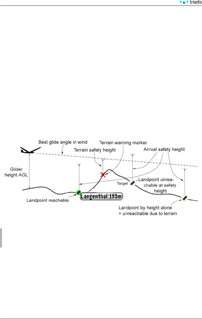
The safety heights are:
• Arrival height This is the elevation above ground at which the glider is required to arrive at for
a safe landing circuit, plus some safety margin. This value is used in final glide calculations
as well as the determination and display of reachable landable fields.
• Terrain clearance This is the elevation above ground, below which any computed glide path
is considered to provide inadequate clearance to the terrain. The terrain clearance value
affects the glide range display, and if the final glide at any point dips below the terrain clear-
ance elevation above ground, a warning marker (large red cross) is drawn on the screen.
If the terrain elevation model is invalid or out of range, then the glide range display and the
terrain warning marker is disabled.
• Break-off height This is the elevation above ground, below which it is recommended for pilots to
consider the cross-country task failed and to concentrate on finding a suitable field to land
in. Currently this break-off height does not affect XCSoar in any way but it is reserved for
future use to provide warnings etc.
These may be set to zero but this is highly discouraged since all glide computers,
instruments and data sources (such as terrain elevation models) are subject to some
degree of error and the atmosphere through which the glider flies is also unpredictable.
XCSoar determines the height above sea level of any turn point or landing point either from the
waypoint file, of if no height is specified in the waypoint file, from the terrain file.
Landable fields are only marked as reachable if the estimated arrival elevation above ground is
above the arrival altitude safety height, and the glide path does not intersect the terrain clearance
safety elevation. The estimated arrival altitude (above safety height) displayed next to landable
waypoints is calculated for best glide angle at zero MacCready ring setting (Mc= 0), adjusted for
wind.
At all times, if the final glide through terrain marker (a red cross) is displayed on the screen, then
the glider must climb in order to safely reach the destination.
51 XCSoar Manual (Altair version) • XCSoar-A-EN