
User manual

XCSoar User Manual
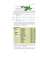
CONFIG . Setup Wind
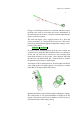
The trail drift display is useful also to show more clearly when
thermals are cranked due to wind shear.
The trail width can be adjusted in the configuration settings.
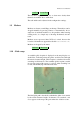
3.9 Markers
Markers are shown as small flags on the map. The markers can be
dropped manually, by pressing a button, or automatically. An ex-
ample use of automatic markers is to drop markers when entering
circling mode, as a simple way of showing all thermals encoun-
tered.
Markers are not preserved after XCSoar is exited, however the
location of all marks are appended to the file xcsoar-marks.txt.
Markers are dropped by the menu:
DISPLAY . Mark drop
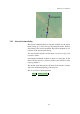
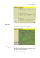
3.10 Glide range
A reachable glide footprint is displayed on the map display as a
dashed line, indicating where the glider would descend through
the terrain clearance height. This footprint is calculated for tracks
extending in all directions. The reachable glide footprint is useful
in assessing range with respect to topology when searching low
for lift, and when flying in mountainous areas.
The final glide path is checked for whether the glider clears terrain
by the terrain clearance height. If clearance is not attained, a red
cross appears on the map at the point where the violation occurs.
42