
User manual

XCSoar User Manual
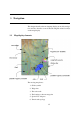
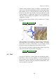
Terrain is phong-shaded to improve visibility. Currently the shad-
ing is set up so that the virtual lighting position is the wind bearing,
thus brighter areas are on the upwind side of hills and dark areas
in the lee of the hill. The amount of phong shading and overall
terrain brightness is configurable. Support for a sun ephemeris is
underway. Terrain shading and brightness can be adjusted in the
configuration settings.
Both terrain and topology display can be switched on or off from
the menu:
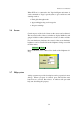
DISPLAY . Terrain toggle
Topology Terrain
If the terrain file is not specified (or terrain display is turned off),
the background colour of the map window is white. All terrain
below mean sea level is coloured blue. If you are flying outside
the terrain region, the background colour will also be blue.
The screen can be de-cluttered, turning off the display of topology
labels and non-task waypoint labels by toggling:
DISPLAY . Declutter labels
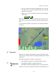
3.8 Trail
An optional ’snail trail’ is drawn on the map showing the glider’s
path history. The colour and thickness of the trail depends on
the variometer value; with lift areas being presented in green and
thicker lines, sink areas being presented in red with thin lines. Zero
lift is presented as a grey line.
40