
User manual

XCSoar User Manual
Waypoints are optionally labelled according to one of several ab-
breviation schemes.
XCSoar continually calculates which landing points are within
gliding range using the current wind estimate. The estimated ar-
rival altitude above the arrival safety height of reachable landable
points is optionally displayed next to the waypoint. This arrival
altitude is calculated at the MacCready setting of zero.
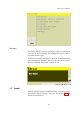
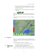
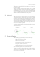
3.6 Active task
The active task course is drawn on the map as a green dashed line.
Assigned area tasks also show the task sectors or areas as a shaded
region. The start and finish waypoint additionally show black cir-
cles and grey lines representing the start and finish zones or lines.
Circles are always drawn around start and finish points, lines are
only drawn if the start/finish points are of line type. Task observa-
tion sectors are drawn as segments.
At all times a thick black line is drawn from the glider to the next
waypoint in the task.
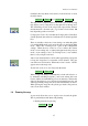
Start/finish Sector Barrel
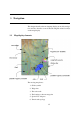
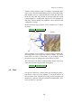
3.7 Terrain and Topology
The following topological features are drawn on the map:
• Major roads, shown as red lines
• Rivers, shown as blue lines
• Large water bodies (lakes), shown as blue areas
• Large cities, shown as yellow areas
• Small population areas, shown as yellow diamonds
Cities and small population areas are labeled in italics.
Terrain is coloured according to height, and optionally shaded by
sun direction or lift-generating slope. Invalid terrain, or terrain
below sea level is coloured blue.
39