
User manual
XCSoar User Manual
7. Markers
8. Trail
9. Glide range
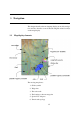
The map is drawn in a projected coordinate system (not latitude
and longitude), and the scale can be changed (zooming in and out),
as well as panned. All navigation functions take the curvature of
the Earth into account.
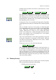
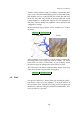
3.2 Glider symbol, map orientation
The glider symbol shows the position of the glider on the map.
The orientation of the glider indicates the estimated heading of the
glider.
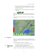
The map is oriented in one of two ways, depending on the flight
mode and the configuration settings:
North-up : Here the map is always oriented with true north up. The
glider symbol is rotated according to its track corrected for
wind.
Track-up : Here the map is oriented so that the glider’s track made good
is up. The north arrow symbol points to true north. The
glider symbol may be shown rotated according to the com-
puted heading of the glider taking wind into account.
Configuration settings can be used to further specify north or target-
up when in circling mode. These are useful to prevent disorienta-
tion when looking at the map while circling. Target-up when cir-
cling makes it easy to determine which direction to exit the ther-
mal.
When in North or target-up in circling modes, the glider symbol is
centered on the screen. Otherwise the glider symbol is positioned
20% from the bottom of the screen, giving a good view of the map
ahead of the glider. This position is adjustable in the configuration
settings.
3.3 Zoom and map scale
To change the scale of the map, for PC or Pocket PC:
1. Tap on a blank part of the map to highlight the map if it is
not already selected.
2. Then use the Pocket PC up/down key to either zoom in or
out.
36