
User manual

XCSoar User Manual
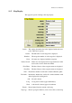
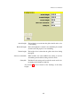
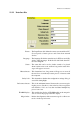
Orientation : This determines how the screen is rotated with the glider.
North up : The moving map display will always be orientated north
to south and the glider icon will be rotated to show its
course.
Track up : The moving map display will be rotated so the glider’s
track is oriented up.
North up when circling : This is equivalent to track-up in cruise and north-up
when circling.
Target up when circling : This is equivalent to track-up in cruise and the bearing
to next waypoint up when circling.
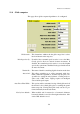
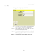
Auto zoom : Determines whether auto-zoom is enabled. Auto-zoom changes
the zoom level during flight so that the map zooms in as the
active waypoint is approached. After passing a waypoint,
the map zooms out to the next waypoint.
Circling zoom : This determines whether separate zoom levels will be main-
tained for circling and cruise modes. If unchecked, there
is only one zoom. If enabled, then the map will zoom in
automatically when entering circling mode and zoom out
automatically when leaving circling mode.
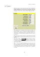
Topology file : Specifies the file defining the topological features. The topol-
ogy file defines the map topology in terms of points, lines
and areas with optional labels.
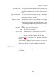
Idle blank screen : This determines whether the display should be blanked after
60 seconds of inactivity when running on batteries. Blanked
screens have a significantly reduced drain on the battery.
The screen can be turned on again by pressing any button.
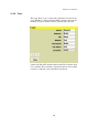
Trail width : Sets the width of the snail trail display.
132