
User manual


XCSoar User Manual
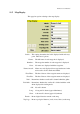
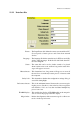
11.5 Map Display
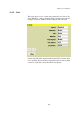
This page has options relating to the map display.
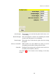
Labels : This setting determines the label displayed with each way-
point. There are 6 options:
Names : The full name of each waypoint is displayed.
Numbers : The waypoint number of each waypoint is displayed.
None : No names are displayed with the waypoints.
Names in task : Names are only displayed for waypoints that are in the
active task as well as the home airfield.
First Three : The first 3 letters of the waypoint name are displayed.
First Five : The first 5 letters of the waypoint name are displayed.
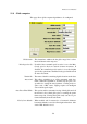
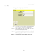
Trail : Determines whether a snail trail is drawn behind the glider.
Trail drift : Determines whether the snail trail is drifted with the wind
when displayed in circling mode.
Off : No trail is drawn
Long : A long trail is drawn (approx 60 minutes)
Short : A short trail is drawn (approx 10) minutes
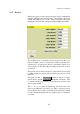
Terrain : Draws digital elevation terrain on the map
Topology : Draws topological features (roads, rivers, lakes) on the map
131