Glide Computer and Navigation System User Manual Manual version 1.4 September 14, 2006 For XCSoar version 5.0 http://xcsoar.sourceforge.
Contents 1 2 3 4 Introduction 1.1 Organisation of this manual 1.2 Notes . . . . . . . . . . . 1.3 System requirements . . . 1.4 Downloading XCSoar . . . 1.5 Installation . . . . . . . . 1.6 Running XCSoar . . . . . 1.7 Through-life support . . . 1.8 Training . . . . . . . . . . 1.9 Using XCSoar safely . . . User Interface 2.1 Button labels and menus 2.2 InfoBoxes . . . . . . . . 2.3 Status messages . . . . . 2.4 Dialog windows . . . . . 2.5 Sounds . . . . . . . . . . 2.6 Screen . . . . . . . . . . 2.
XCSoar User Manual 4.3 4.4 4.5 4.6 4.7 4.8 4.9 4.10 4.11 4.12 4.13 4.14 4.15 4.16 5 6 7 Waypoint selector dialog . . . Task editor dialog . . . . . . . Advancing and restarting tasks Task rules . . . . . . . . . . . Alternate starts . . . . . . . . Task calculator dialog . . . . . Task status dialog . . . . . . . Assigned Area Tasks . . . . . OnLine Contest . . . . . . . . Abort/resume task . . . . . . . Logger . . . . . . . . . . . . . Logger replay dialog . . . . . Analysis dialog . . . . . . . .
XCSoar User Manual 7.1 7.2 7.3 7.4 7.5 7.6 7.7 7.8 7.9 7.10 8 9 Airspace display . . . . . . . . . . Incursion events . . . . . . . . . . Airspace warning levels . . . . . . Airspace warning dialog . . . . . Airspace warning acknowlegement Airspace queries . . . . . . . . . . Airspace filter dialog . . . . . . . Analysis dialog . . . . . . . . . . FLARM traffic display . . . . . . Team flying . . . . . . . . . . . . Avionics and Airframe 8.1 Battery life . . . . . . . 8.2 GPS connection . . . . . 8.
XCSoar User Manual 11.3 Airspace Display . . . . . . . 11.4 Airspace Colours and Patterns 11.5 Map Display . . . . . . . . . . 11.6 Glide computer . . . . . . . . 11.7 Safety factors . . . . . . . . . 11.8 Polar . . . . . . . . . . . . . . 11.9 Devices . . . . . . . . . . . . 11.10Units . . . . . . . . . . . . . . 11.11Interface files . . . . . . . . . 11.12Appearance . . . . . . . . . . 11.13Vario gauge . . . . . . . . . . 11.14Task . . . . . . . . . . . . . . 11.15Task Rules . . . . . . . . . . . 11.
XCSoar User Manual A GNU General Public License 6 164
Preface Revision history Revision Release date Changes 0.2 EN 1.0 EN 1.01 EN 6 March 2006 26 March 2006 11 April 2006 1.1 EN 1.2 EN 1.3 EN 1.4 EN 29 May 2006 17 August 2006 30 August 2006 13 September 2006 Reorganised, reformatted First release Minor edits, new features described Incorporate changes to V4.7.5 Incorporate changes to V4.7.8 First build of XCSoar v4.7 portrait Release of XCSoar v5.0 on all platforms This manual applies to XCSoar version 5.0.0.
XCSoar User Manual Limited liability In no event shall XCSoar, or its principals, shareholders, officers, employees, affiliates, contractors, subsidiaries, or parent organizations, be liable for any incidental, consequential, or punitive damages whatsoever relating to the use of the Product. Disclaimer This product, and all accompanying files, data and materials, are distributed ”as is” and with no warranties of any kind, whether express or implied. This product is used entirely at the risk of the user.
1 Introduction This document is a pilot’s manual for XCSoar, an open source glide navigation system for Pocket PC devices. The audience is assumed to have a sound knowledge of the fundamental theory of flight for gliders, and at least a basic working knowledge of crosscountry soaring. Updates to the XCSoar software may result in some of this manual being out of date. You should read the release notes distributed with the software to keep track of changes.
XCSoar User Manual of the software is described in detail in Chapter 11. The formats of the various data files that program uses, as well as where to obtain them from and how to edit them, is described in Chapter 12. Finally, a short history and discussion of XCSoar’s development process is presented in Chapter 13. 1.2 Notes Terminology A variety of terms may be used to describe Pocket PC devices, including ‘organiser’ and Portable Digital Assistant (PDA).
XCSoar User Manual two GPS devices may be used simultaneously, giving XCSoar a degree of redundancy of the GPS fixes. Altair : The Altair glide computer by triadis Engineering is a glide computer factory installed with XCSoar. The Altair PRO version also contains an internal GPS. 1.4 Downloading XCSoar The software is available as a free download from the XCSoar website http://xcsoar.sourceforge.net. Follow the links to the download section.
XCSoar User Manual Additional files Additional data files, such as terrain and topology, special use airspace, waypoints etc. can also be downloaded. The files used by XCSoar are described in Chapter 12. All data files should be copied into the directory: My Documents/XCSoarData For PDA users, data can also be stored on the operating system file store, on Compact Flash cards or SD cards under the directory XCSoarData. For example: SD Card/XCSoarData IPAQ File Store/XCSoarData 1.
XCSoar User Manual 2. Run the installation program Install-XCSoar-XXX-YYY.exe (where XXX and YYY refer to the version number and operating system version respectively). 3. Read and accept the license 4. Follow the prompts in the installation program and also follow the prompts on the organiser. 5. XCSoar is now installed. 6. Perform a reset of your device. See the operating instructions for your organiser about how to do this. 7.
XCSoar User Manual It is a good idea to assign one of your PocketPC hardware buttons to run XCSoar. See your PocketPC manual for details of how to do this. Owners of Compaq Aero PocketPCs may find it useful to enable ‘Game Keys’. Installation of Pocket PC version from a Pocket PC CAB file You can download the CAB file appropriate for your organiser and install it onto a nonvolatile storage card like a Compact Flash or Secure Digital card. Place it in your organiser.
XCSoar User Manual 1.6 Running XCSoar Two versions of XCSoar are available, FLY and SIM. FLY : This mode is used when actually flying. The simulator is disabled and serial communications are active. SIM : This starts XCSoar in simulator mode, no serial communications are attempted. The simulator contains a simple interface allowing the user to fly the glider about.
XCSoar User Manual XCSoar PC version The program can be run by opening the explorer window, find the C:\XCSoar directory, and double clicking on the program file: FLY : Run XCSoarPC.exe SIM : Run XCSoarPCSim.exe Start-up and user profiles When XCSoar starts up, it displays a small window with a safety reminder. To proceed, press Enter (to acknowledge the reminder). There is also a data field that allows the user to select a profile from a list.
XCSoar User Manual Last flight statistics The previous flight’s statistics are saved when XCSoar exits, and loaded at startup. This allows the flight to be reviewed after shutting down Altair. Statistics are reset on takeoff so they will not affect the next flight. Exiting the program For PDA and PC versions, XCSoar is shut down from the menu: INFO . INFO . INFO . Exit For PC versions, XCSoar can also be shut down by clicking the close icon on the XCSoar window.
XCSoar User Manual configuration settings and data files will be preserved during the re-installation/upgrade. It is also recommended to periodically check for updates to data files, particularly Special Use Airspace, which may be subject to change by the national civil aviation authority. Like any complex software program, XCSoar may be subject to software bugs, so if you find any, please report them to the XCSoar developers by using the bug tracker at http://sourceforge.
XCSoar User Manual Using XCSoar with a flight simulator A good way to learn how to use XCSoar is to connect the Pocket PC device to a PC running a flight simulator that can output NMEA sentences to the serial port. Suitable simulators include Condor and X-Plane. The benefit of this form of training is that XCSoar can be used in FLY mode, so it behaves exactly as if you were really flying, and you can get a good feel for how the program works while you are flying the simulator. 1.
2 User Interface This chapter describes the fundamental user interface concepts used by XCSoar, and is intended as an overview. More detailed descriptions are given in following chapters. The XCSoar display is composed of several parts: Map area : The bulk of the screen is dedicated to the GPS moving map display. Various symbols relating to glide computer information are overlaid on the map area.
XCSoar User Manual Button labels and menus : Hardware buttons on the Pocket PC can be used to bring up and navigate smaller onscreen menus that are typically laid out such that menu items can be selected by pressing the button adjacent to the item. If the Pocket PC has a touch screen, then menu items can be selected by touching them. These buttons are drawn in black text on a green background. Status messages : Text is displayed over the map area in status message boxes.
XCSoar User Manual 2.1 Button labels and menus The button menu is a set of buttons drawn on the screen and activated by touch or hardware button presses. Using buttons and the button menu are the primary ways the user interacts with XCSoar. Interface basics The menu is organised into different groups of functions, usually in the form of a hierarchy.
XCSoar User Manual On the PDA version, the mode buttons are activated by the keys to the side of the joystick/rocker button. By convention, buttons labeled with a trailing slash, e.g. NAV/ means that pressing the button will show more items. Buttons labeled with a leading slash, e.g. /NAV means that pressing the button will close that menu. If the user doesn’t interact with the computer for a long time, the menu will close automatically. This menu timeout is configurable.
XCSoar User Manual Task Edit Task Save Task Abort Force Final Team code Displays the task editor Saves the current task to the default, so when restarting XCSoar, the task is restored. Aborts/resumes the current task. Toggles between automatic and forced final glide mode. Displays the team code dialog.
XCSoar User Manual Declutter Labels Toggles display of topology and non-task labels CONFIG menu MacCready + MacCready − MacCready Auto Setup Basic Wind Vario/ Setup System Settings Airspace Logger Record Logger Replay Increases MacCready value Decreases MacCready value Toggles automatic MacCready when in final glide. Displays the basic settings (bugs/ballast/QNH) dialog Displays the wind settings dialog Control of Vega intelligent variometer, this comprises a submenu.
XCSoar User Manual Check List Analysis Status System Status Aircraft Status Task Aux Infobox Message Repeat Exit Displays the check list dialog. Displays the analysis/statistics dialog. Displays the system status dialog. Displays the aircraft status dialog. Displays the task status dialog. Toggles the infobox display between normal (flight-mode specific) or auxiliary infobox display. Repeats the last status message. Exits from XCSoar after asking for confirmation.
XCSoar User Manual ASI Zeros the airspeed indicator. Zero Accel Zero Store Cruise Demo Climb Demo Levels/zeros the accelerometers. Stores Vega settings to EEPROM Activates Vega variometer cruise tone demo Activates Vega variometer climb tone demo Pan mode Pan Turns pan mode off Zoom In Zoom Out Nearest Waypoint Zooms in the map display Zooms out the map display Displays the waypoint details dialog of the waypoint nearest to the aircraft.
XCSoar User Manual Down key : Left key : Right key : Enter : Zoom out Auto-Zoom toggle Pan toggle Clear status message or acknowledge airspace warning For the Altair version in the default mode, the rotary knob performs the following functions: Outer knob counterclockwise : Zoom in Outer knob clockwise : Zoom out Inner knob counterclockwise : (No function assigned) Outer knob clockwise : (No function assigned) Knob button press : Clear status message or acknowledge airspace warning In dialog forms, the r
XCSoar User Manual Screen display modes The main display can be presented with the map area and InfoBoxes, or a full-screen map. The screen mode can be toggled between the following: • Small map area, with flight-mode specific InfoBoxes • Small map area, showing auxiliary InfoBoxes. • Full-screen map area, with InfoBoxes hidden. This is performed by selecting the menu: DISPLAY . Full screen At any time the InfoBoxes may be toggled between auxiliary and normal from the menu: INFO .
XCSoar User Manual 1. Highlight the item you wish to modify, by touching the InfoBox. The box title border will change colour indicating it is selected. 2. Press the up/down/left/right or enter button on the Pocket PC to change the value. Different InfoBoxes allow different buttons to be used. 3. The value is now changed. 4. After 10 seconds or so have elapsed without further button pressing, the InfoBox will be deactivated so there is no risk of accidental adjustment later. 2.
XCSoar User Manual plex interactions with the user, such as editing tasks and configuration settings. Some dialogs simply display information, and require no user input. Other dialogs contain data fields that can be modified or buttons that can be pressed. A cursor appears over the active button or data field. This cursor appears as a black border around the corners of the button or field.
XCSoar User Manual Task calculator : Allows the pilot to see the effect of various changes to the task on final performance. Analysis : Shows several pages of analysis and statistics about the flight. Status : Status dialogs give one page summaries of the situation. Checklist : A multi-page custom checklist. Configuration : Allows XCSoar and certain connected devices to be configured. Airspace colours and patterns : Configuration of colours and patterns of airspace used on the map display.
XCSoar User Manual Text entry A text entry dialog is used for entering text. This is used for team code entry as well as entering other configuration options, such as pilot name for the logger. To enter text, rotate the inner knob to adjust the character under the cursor (underlined character), and rotate the outer knob to move the cursor left/right. Press enter or escape to exit. 2.5 Sounds XCSoar generates sounds for different events, and can be configured to have custom sounds for any event.
XCSoar User Manual When XCSoar is connected to the Vega intelligent variometer, it sends commands to Vega’s speech system, to give verbal cues and warnings such as: • Final glide through terrain • Approaching/passing a task waypoint • Airspace warnings 2.6 Screen Certain aspects of the look of items on the screen can be adjusted. The most noticeable of these is whether to display InfoBoxes and gauges in black on white (called inverse colours) or white on black.
3 Navigation This chapter describes the moving map display as an aid to navigation, and also describes some of the task and glide related overlays on the map display. 3.1 Map display elements The moving map shows: 1. Glider symbol 2. Waypoints 3. The active task 4. The bearing to the next waypoint 5. Special Use Airspace 6.
XCSoar User Manual 7. Markers 8. Trail 9. Glide range The map is drawn in a projected coordinate system (not latitude and longitude), and the scale can be changed (zooming in and out), as well as panned. All navigation functions take the curvature of the Earth into account. 3.2 Glider symbol, map orientation The glider symbol shows the position of the glider on the map. The orientation of the glider indicates the estimated heading of the glider.
XCSoar User Manual On Altair, the rotary knob can be used to zoom in and out, or select from the menus: DISPLAY . Zoom in and DISPLAY . Zoom out The map scale is displayed in the lower left corner of the moving map display, and as a striped bar on the right side of the map area. The alternating colours in the striped bar represent the distance measurement in a decimal scale, (e.g. 0.1 km, 1 km, 10 km, 100 km) depending on the zoom level. Compaq Aero Users.
XCSoar User Manual 2. The map can then be panned by dragging the screen or using the cursor keys. For Altair, panning is performed with the inner/outer rotary knob. 3. When done, pan mode should be disabled, by activating the menu again: DISPLAY . Pan When pan is active, the text ’PAN’ appears next to the map scale. The location of focus moves and rotates with the glider when panning. A special menu of buttons in pan mode is also displayed when in pan mode. 3.
XCSoar User Manual Waypoints are optionally labelled according to one of several abbreviation schemes. XCSoar continually calculates which landing points are within gliding range using the current wind estimate. The estimated arrival altitude above the arrival safety height of reachable landable points is optionally displayed next to the waypoint. This arrival altitude is calculated at the MacCready setting of zero. 3.6 Active task The active task course is drawn on the map as a green dashed line.
XCSoar User Manual Terrain is phong-shaded to improve visibility. Currently the shading is set up so that the virtual lighting position is the wind bearing, thus brighter areas are on the upwind side of hills and dark areas in the lee of the hill. The amount of phong shading and overall terrain brightness is configurable. Support for a sun ephemeris is underway. Terrain shading and brightness can be adjusted in the configuration settings.
XCSoar User Manual If Vega or an intelligent variometer is connected with Netto output, the Netto vario value is used; hence the colours and thickness of the trail indicates the air-mass vertical movement rather than the glider’s vertical movement. The snail trail display can be toggled between off, a short trail (about ten minutes) or a long trail (about one hour). This can be performed permanently through the configuration settings or temporarily by the menu: DISPLAY .
XCSoar User Manual CONFIG . Setup Wind The trail drift display is useful also to show more clearly when thermals are cranked due to wind shear. The trail width can be adjusted in the configuration settings. 3.9 Markers Markers are shown as small flags on the map. The markers can be dropped manually, by pressing a button, or automatically. An example use of automatic markers is to drop markers when entering circling mode, as a simple way of showing all thermals encountered.
XCSoar User Manual 3.11 Aircraft status dialog The nearest landmark function, typically available via the button menu, brings up a status message describing the name, distance and bearing to the nearest landmark. The nearest landmark is also reported on the aircraft status dialog. You may find this function useful when you need to report your location to others. Currently the landmarks scanned are the list of waypoints.
XCSoar User Manual 44
4 Cross Country Tasks XCSoar provides a full task management system, in which tasks can be edited prior to flight and, when undertaking casual crosscountry flying, modified during flight. Waypoints are advanced automatically or may be cycled through manually. This chapter also describes the use of IGC loggers with XCSoar. 4.1 Editing tasks You can edit tasks in several ways.
XCSoar User Manual 4.2 Waypoint details dialog The waypoint details dialog describes a waypoint in detail and has navigation functions such as GOTO, Insert. This may be accessed several ways: • From the task editor, menu NAV . Task Edit and select a waypoint, then select the Details button. • From the menu INFO . Waypoint details details for the active waypoint. to show the • From the menu INFO .
XCSoar User Manual This page also shows three forms of altitude difference (additional altitude required to reach the waypoint at the safety altitude) for the corresponding waypoint: Alt diff Mc 0 : Altitude difference at Mc setting of 0 Alt diff Mc safety : Altitude difference at the abort/safety MacCready setting Alt diff Mc current : Altitude difference at the current MacCready setting Task menu This page contains a column of buttons allowing various actions to be performed: Goto (and clear task) : canc
XCSoar User Manual Satellite image This page shows a satellite image of the waypoint. 4.3 Waypoint selector dialog The waypoint selector is a dialog that allows waypoints to be easily selected from a potentially large database.
XCSoar User Manual • From the menu NAV . Waypoint lookup • From the task editor, menu NAV . Task Edit and select a waypoint, then select the Select button. The waypoint selector comprises a set of optional filters on the left side of the page, and a list of matching waypoints on the right. There are several filters available, which may be used together, individually or not at all. Name : Filtering based on the matching the first letter in the waypoint name.
XCSoar User Manual ing on what function opened the waypoint selector. In typical use it brings up the waypoint details dialog for the selected waypoint. 4.4 Task editor dialog The task editor is used to edit and view cross country tasks. This is accessed via the menu NAV . Task Edit The task editor’s primary page is the Task Overview page which comprises a list of task waypoints on the right side of the form.
XCSoar User Manual Pressing the Advanced button exposes (or hides) several more fields. Pressing it again hides the fields. File : This field defines the task file slot to be used by save/load functions. Up to 20 tasks can be stored. Save : Saves the task to the specified slot number Load : Loads the task from the specified slot number Calc : Opens the task calculator dialog (see Section 4.8). Declare : Sends the task declaration to the logger (if available).
XCSoar User Manual Moving the cursor down to a task waypoint in the Task Overview page and pressing enter will select that waypoint for editing. New waypoints can be added to the task by selecting the “(add new waypoint)” line. Either the home waypoint or start waypoint is assigned to the new task waypoint, making it quick and easy to define triangular or out and return tasks. Once a waypoint is thus selected, a task waypoint dialog appears. These are different for Start, Turn-point and Finish points.
XCSoar User Manual The Edit start points button allows editing of alternate start points. See Section 4.7 for more details. The task waypoint dialog for turn-points in non AAT-tasks do not contain any editable fields. For both AAT and non AAT tasks, the finish waypoint dialog allows the finish type to be defined: Finish type : Line or cylinder Finish diameter : Diameter of the cylinder or length of the finish line. For AAT tasks, the task waypoint dialog for turn-points allows the AAT areas to be defined.
XCSoar User Manual 4.5 Advancing and restarting tasks At all times one waypoint in the task is designated as the active waypoint. The active waypoint is used for calculation and display of navigation information, that is, the pilot is directed to fly towards the active waypoint (also referred to as the ’next waypoint’ in the description of InfoBoxes as in Chapter 10). During flight a continuous display of the bearing of the next turn point is shown.
XCSoar User Manual Arm auto advance : This is similar to the Auto method, but it requires the pilot to arm a trigger. Therefore, if the advancement conditions are met but the trigger is not armed, the waypoint is not advanced. The ‘Arm’ button can be used to arm the trigger. It is accessed via the menu NAV . Arm advance Arm auto advance start : This is similar to the Auto method but the start must be armed.
XCSoar User Manual Sector turn-points are 90 degree segments aligned to the bisection of the previous and next waypoints, as commonly used in FAI tasks. There is also support for German DAe sectors. Automatic advancement of the start task depends on the type of start: Cylinder : When the glider leaves the cylinder area. Line : When the glider crosses the start line. FAI 90 sector : When the glider crosses the start sector lines.
XCSoar User Manual 4.7 Alternate starts The task system allows alternate start sectors to be defined. To use it, on the task edit page, select the start point, then turn on the ‘Alternate start points’ property. Then press the button ’Edit alternate start points’. To edit the start points, move the cursor to an item in the list on the right side of the dialog, and press enter. This opens the waypoint selector dialog, to allow selection of the waypoint.
XCSoar User Manual In flight, any time you cross a start line (or exit a start cylinder), this will start the task at that particular alternate start. Task statistics are recalculated for the start sector you last flew through. All alternate start sectors are shown on the map. You can re-start simply by flying through the start sector again or another start sector. When the waypoint advance mode is ‘Arm’ or ‘Arm Start’, then a start is only recognised by XCSoar if the advance trigger is armed.
XCSoar User Manual 4.8 Task calculator dialog The task calculator dialog allows the pilot to see the effect of various changes to the task on final performance. This may be accessed several ways: • From the menu NAV . Task calc • From the task editor, menu NAV . Task Edit and select the button Advanced then Calc • From the analysis dialog, menu INFO . Analysis and select the button Calc Assigned task time : This field displays the assigned task time.
XCSoar User Manual 4.9 Task status dialog The task status dialog gives a summary of important task information. It can be useful to give a good overview of the task status while freeing up InfoBoxes for other purposes. This is accessed via the menu: INFO . Status task The task status dialog shows the text “INVALID” in the task start time if no valid start was detected. The task start time is shown normally if a valid start was detected. 4.
XCSoar User Manual Zero range yields a nominal task distance: for sectors the target is half way along the bisector radial; for cylinders the target is in the center of the cylinder. The targets can be modified in two ways: • From the task calculator dialog (see Section 4.8), the Range field adjusts the targets of all remaining waypoints in the task. • From the task editor dialog (see Section 4.4), the range of each waypoint may be individually adjusted.
XCSoar User Manual • What will happen if the conditions deteriorate? The MacCready setting can be decreased and the pilot can see how much the task can be shortened and still finish the task later than the assigned minimum time. • What will happen if I leave the AAT area now? 4.11 OnLine Contest The analysis dialog contains a page ‘OnLine Contest’ which can be used to show the optimal path and estimated score.
XCSoar User Manual When flying OLC, either AAT or non-AAT tasks may still be used to manage the flight navigation. During flight, if the ‘Optimise’ button in the OLC page of the analysis dialog is pressed, the computer will optimise the current flight with respect to the selected OLC rules. In the OLC analysis page, the aircraft track is shown as a thin green line, and after optimisation, the optimal path is shown as a thick red dashed line.
XCSoar User Manual situation, XCSoar can be instructed to ’abort’ the task, and it will then help you reach a safe landing site. To abort/resume the task, press NAV . Abort task When in abort mode, whatever cross-country task was being flown is discarded. The task waypoint list is then filled with nearby landing points, ordered by the estimated arrival altitude at best glide angle with the safety MacCready ring setting, adjusted for wind.
XCSoar User Manual If the task waypoint that was active, prior to aborting the task, is landable and estimated to be reachable, then it remains the active waypoint in abort mode. Otherwise, the most reachable landable waypoint is selected as the active waypoint, even if there are no reachable waypoints.
XCSoar User Manual • The PRO version of Altair has an internal IGC certified logger device. XCSoar communicates with the logger as if it were an external serial device. • XCSoar can also send declarations to some external logger devices, such as the EW logger. For this to work, the device name must be specified in the “COMM ports and Devices” section of the configuration settings. The logger can be turned on and off automatically or manually.
XCSoar User Manual During replay, the word “REPLAY” appears at the lower left corner of the screen. During replay, the program behaves as if real GPS updates are being received by a GPS. The logger replay dialog does not need to be open during replay. To start a log, first select the file to load, and then select the Start button. The replay can be performed in accelerated time by changing the time scale from 1x to a higher number, and paused by setting the time scale to zero.
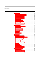
XCSoar User Manual INFO . Analysis Several pages are of interest: Barograph : Shows a graph of the history of the altitude of the glider. Statistics are used to estimate the thermal working band (average base and ceiling of climbs) and to estimate how the ceiling is changing over time. The base and ceiling lines are drawn on the barograph. The ‘Settings’ button opens the basic settings dialog (e.g. to adjust the QNH) Climb history : Shows a bar chart of the average climb rate achieved during each climb.
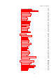
XCSoar User Manual Task : This page shows an overview of the entire task. The main task line is drawn in thick dashed green, AAT areas are shaded. For AAT tasks, the path from the aircraft around the remaining targets within AAT areas is shown in red. The aircraft track is shown as a thin green line. The ‘Task calc’ button opens the task calculator, (e.g. to adjust the AAT task range or Mc value) 4.
XCSoar User Manual terrain and atmospheric conditions may result in poor visibility before the displayed sunset time. For PDA systems, the clock is adjusted for daylight saving time according to the settings in the operating system. For Altair, the clock UTC offset must be adjusted manually for daylight saving time in the configuration settings dialog.
5 Glide Computer This chapter focuses on how XCSoar’s glide computer works and is recommended reading so you understand the specific details of calculations being performed and how to use the software properly. It assumes a basic knowledge of cross-country soaring, but is suitable reading for competition pilots as well as pilots engaging in casual cross-country touring. 5.1 Flight modes XCSoar automatically detects the difference between thermal (circling) flight and cruising flight.
XCSoar User Manual In addition to these display modes, an auxiliary set of InfoBoxes may be displayed in any flight mode. This is useful if the pilot has information he wants to be able to view no matter what mode the computer is in. This is accessed from the menu INFO . Auxiliary infobox which toggles between the normal mode-specific display and the auxiliary display. Final glide mode can also be forced even if the active waypoint is not the final waypoint, by selecting the menu option: NAV .
XCSoar User Manual In addition, an automatic MacCready mode is available as described in Section 5.12. 5.3 Glide polar The glide polar specifications of a small selection of glider types, representing major classes of gliders, are built into XCSoar, and these may be used as an approximation for other gliders if no better glide polar can be found. However, for most accurate results, it is advisable to use the correct glide polar for your particular aircraft type.
XCSoar User Manual The bugs setting (’clean’) determines the amount the polar is degraded due to contamination during a long flight. A ’clean’ setting of 100% will cause the software to use the clean polar. A ’clean’ setting of 50% will degrade the polar by 50%, effectively doubling the sink rate. The ballast setting is used to modify the polar to account for any water ballast carried during the flight. A ballast setting of 100% modifies the polar to account for a full load of water ballast.
XCSoar User Manual The QNH is only updated if the aircraft is on the ground for more than 10 seconds, so that if XCSoar is restarted during flight, QNH will not be adjusted. The update only occurs also if the terrain database is valid at the current aircraft location. 5.5 Speed command display When used in conjunction with an intelligent variometer that produces indicated airspeed measurements, a speed command chevron is drawn on the right side of the map display.
XCSoar User Manual Block speed to fly Dolphin speed to fly
XCSoar User Manual Break-off height : This is the elevation above ground, below which it is recommended for pilots to consider the cross-country task failed and to concentrate on finding a suitable field to land in. Currently this break-off height does not affect XCSoar in any way but it is reserved for future use to provide warnings etc.
XCSoar User Manual 5.8 Final glide calculator The final glide calculator uses many sources of information when determining the altitude required to reach your goal or the next waypoint. These are: • The glider’s polar data; • The wind speed and direction; • The distance and bearing of the goal or waypoint; • The MacCready setting; • The altitude of the waypoint or goal; • A user specified safety margin (arrival height).
XCSoar User Manual Above Below The final glide bar has been modified to show the effect of MacCready setting on the altitude difference to complete the task. The display shows in an arrow outline the altitude difference calculated at zero MacCready, as well as the usual filled arrow that displays the altitude difference calculated at the current MacCready setting. The number shown in the box next to the final glide bar still shows the altitude difference at the current MacCready setting.
XCSoar User Manual Below final glide at Mc= M, and just below at Mc= 0 : Here the display shows that at the current MacCready setting, the aircraft is below final glide (filled red arrow). The hollow red arrow shows that by reducing the MacCready setting to zero, the aircraft is nearly at final glide. Below final glide at Mc= M, and at Mc= 0 : Here the display shows that at the current MacCready setting, the aircraft is below final glide (filled red arrow).
XCSoar User Manual The glide computer assumes the glider’s average cross-country speed is equal to that achievable under classic MacCready theory taking wind into account, with the current MacCready setting. The next major release of XCSoar will allow several ways of calculating time estimates: • MacCready speed (as currently implemented) • Task average, the average speed achieved on this task.
XCSoar User Manual if the display is oriented ‘Track-Up’, then steer so the blue arrow points directly up. The glide computer accounts for wind drift during circling to provide an ‘optimal cruise track’ vector, which indicates the track the glider should follow during cruise such that it will arrive at the waypoint in minimum time. This vector is displayed on the map as a blue arrow.
XCSoar User Manual The method that is used is defined in the configuration settings dialog as the field ‘Auto Mc Mode’. The default setting is ‘final glide’. To enable/disable Auto MacCready, use the menu CONFIG . MacCready Auto When Auto MacCready is enabled, the MacCready infobox displays ‘AUTO’ instead of ‘MANUAL’; and the MacCready indicator in the variometer gauge displays ‘AutoMc’ instead of ‘Mc’. The Auto MacCready methods are described in further detail below.
XCSoar User Manual Average climb This method sets the MacCready to the average climb rate achieved across all thermals in the current flight. As such, it takes into account the time spent centering the thermal. The value is updated after leaving a thermal.
XCSoar User Manual In this dialog page, the ‘Settings’ button opens the basic settings dialog (e.g. to adjust the bugs/ballast). The glide polar page of the analysis dialog shows the average total energy sink rate at each speed achieved in flight, when connected to a supported intelligent variometer (e.g. Vega). This facility allows pilots to perform test flights in stable atmospheric conditions, such as on calm days with no wind, and inspect the measured glide polar.
6 Atmosphere and Instruments XCSoar maintains an internal model of the atmosphere based on statistics gathered from the flight path and other instruments connected to the Pocket PC device. These statistics and measurements are approximate and the weather can on some days change rapidly. The pilot should at all times keep observing the weather. In particular, when out-landing in fields, the pilot should look for indicators on the ground to confirm wind strength and direction. 6.
XCSoar User Manual Currently XCSoar supports the triadis Engineering Vega intelligent variometer, the Cambridge 302 DDV, Borgelt B50/B500, and LX Navigation LX1600 variometers. Note that the level of support for each device varies, and not all manufacturers release their protocols to allow the XCSoar developers to provide full support. For Vega, a small icon displaying a circling glider is displayed when the variometer is in climb audio mode. 6.
XCSoar User Manual 6.4 Wind estimation XCSoar offers two ways of estimating wind during flight. Circling : This method uses GPS position fixes to estimate the wind based on drift, typically while thermalling; and is available on all XCSoar installations. ZigZag : This method uses GPS position fixes and true airspeed measurements to estimate the wind, typically during cruise. It is only available where XCSoar is connected to an intelligent variometer that outputs true airspeed.
XCSoar User Manual • Both (ZigZag and Circling) Circling wind algorithm XCSoar estimates the wind magnitude and direction when circling. It does this using a sophisticated algorithm that incrementally improves the wind estimate from completed turns. Poor quality turns, where the bank angle changes significantly, are rejected or have minimal impact on the overall wind estimate. The best turns are those with constant bank angle.
XCSoar User Manual CONFIG . Wind The wind value can be saved so that the estimate is restored next time XCSoar starts. At any time during flight, the pilot can make corrections to the wind estimate by entering the correction in the wind settings dialog and pressing the Save button. The automatic wind algorithm may also be switched on or off in this dialog. 6.6 Thermal profile Statistics on climb rates in thermals are collected and displayed in a thermal band meter.
XCSoar User Manual the shaded area. This scaling and arrow makes it easy to see how the pilot’s MacCready setting compares with achieved thermals and to plan the desired working height band. When cruising between thermals, the vertical position of the arrow, indicating the glider’s height relative to the thermal band, can be used as a reference to suggest how urgent it is to find the next thermal.
XCSoar User Manual if you leave a thermal at the top and later return at low altitude, the position on the map shows the predicted location of the thermal at that low altitude (which is further upwind than the top). If the wind changes and the thermal source is still active, its position on the map reflects the wind change; that is, the thermal at altitude will be projected downwind at the new wind estimate. 6.
XCSoar User Manual The forecast cloud base is determined by the altitude at which the dew point intersects the maximum forecast temperature on the ground, cooled adiabatically as it rises according to the dry adiabatic lapse rate. If no clouds are forecast, the cloud base is reported as zero. 6.9 Analysis dialog The analysis dialog is used to see several aspects of the atmosphere. This is accessed via the menu under: INFO .
XCSoar User Manual The climb history and barograph pages, described in Section 4.15, are also useful to determine trends in the soaring conditions.
7 Airspace, Traffic and Team Flying A database of Special Use Airspace (SUA) can be loaded into XCSoar and used for both display of the airspace regions as well as detecting when the glider enters and leaves the regions. Two airspace files can be set in the configuration settings. The first of these is intended for use as the primary SUA database, the second is intended for use with short-term or changing airspace such as the airspace defined in NOTAMs.
XCSoar User Manual The patterns used to display airspace areas include opaque, transparent (hollow) and several hatched and stippled patterns. The non-opaque patterns are partially transparent with respect to terrain and topology but are not transparent with respect to overlapping airspace. However, where overlapping airspace occurs, all borders are visible. That is, even though airspace patterns are not mutually transparent, all airspace borders are drawn on top of the airspace areas.
XCSoar User Manual Leaving : This event occurs when the glider leaves an airspace region. In all cases, the boundary of the region is defined by maximum and minimum altitudes or flight levels, as specified in the airspace file. Airspace warnings are still issued even if the incursion region is off-screen. Where a barometric altitude source is available, it is used preferentially to GPS altitude in detecting airspace incursions.
XCSoar User Manual 7.4 Airspace warning dialog The airspace warning dialog contains a list of up to 4 individual warnings. The list item backgrounds are coloured RED if the glider is inside, and YELLOW if outside. If the warning is acknowledged, the text is greyed out. Each list item occupies two rows, and includes the following details: ...
XCSoar User Manual This means that the aircraft is inside the Class C airspace ‘Bern CTRgld’, with base of terrain surface and ceiling at 1350m. At any time, the airspace warning dialog can be opened by selecting the menu: INFO . Nearest Airspace If well outside all airspace, this menu item just displays a simple status message indicating details on the nearest airspace. 7.
XCSoar User Manual • The warning system beep only occurs when the warning level increases. • The warning system is designed to allow circling near an airspace without over-stressing the pilot with extraneous warnings. When an airspace region is acknowledged, the region is drawn on the screen without a pattern.
XCSoar User Manual INFO . Nearest airspace This returns at most a single airspace region. The search is limited to 100 km range. If the glider is outside the airspace, it also describes the distance and bearing to the nearest point on the airspace perimeter to the glider. If the glider is inside the airspace, it also describes the distance and bearing to the nearest exit. 7.
XCSoar User Manual INFO . Analysis The display shows along the horizontal direction, the distance from the glider out to 50 km in the direction of the glider’s track; along the vertical direction is height. The height of the glider is indicated by a white arrow. This page is useful to help visualise complex layering of airspace. The ‘Nearest’ button opens the airspace warning dialog if close to airspace. 7.
XCSoar User Manual This FLARM display is oriented track-up and a small glider icon clearly shows that the display is oriented as such. The scale of the display is nonlinear (expanded close to the aircraft). On the background there are three rings; the first is 500 meters, the second is 1000 meters and the third is 2000 meters. Traffic further away than 2000 meters is drawn at the 2000 meter ring. The FLARM gauge display shows FLARM traffic in colours according to the threat level.
XCSoar User Manual It is possible to configure XCSoar to change the map display zoom level or announce arrival and departure of FLARM traffic with status messages. Display on the map FLARM of aircraft registration or pilot name is made possible via a look-up of the ICAO aircraft ID of FLARM traffic in a file. See Section 12.15 for details on this file format. Aircraft with the FLARM privacy flag set will not have any identification displayed. 7.
XCSoar User Manual During flight, the pilot can read out his ‘Own code’ from the team code dialog to his team mate, in order to report his position. When the pilot hears a code report from a team mate, he presses the ‘Mate code’ button to open the text entry dialog to allow entry of the mate’s code. Refer to the ‘text entry dialog’ description below for how to edit the text. After entering the mate’s code, the relative distance and bearing to the mate is calculated and updated in the dialog.
8 Avionics and Airframe This chapter discusses XCSoar as a subsystem of the aircraft. It covers the integration of XCSoar with external devices, including GPS, switches and sensors, and aircraft radio transceivers and other devices. Integration with FLARM is covered in Chapter 7, and integration with variometers is covered in Chapter 6. 8.
XCSoar User Manual GPS status GPS status icons and text may appear on the bottom edge of the map display to indicate: Waiting for GPS fix : The GPS may have a 2D fix, better reception or additional time to search for satellites is required. The aircraft symbol disappears while there is no 3D fix. GPS not connected : No communication with the GPS is received. This indicates an error in the Comm port settings or the GPS device may be disconnected or switched off.
XCSoar User Manual Bluetooth device : Many Pocket PC devices support wireless connection to a Bluetooth Game-Pad device that has several buttons. This is more suited to user-interface input devices than airframe monitoring. A custom ‘input events’ file determines how switch and sensor inputs are processed.
XCSoar User Manual 8.5 Aircraft radio transceiver Monitoring and setting the active and standby frequencies of aircraft transceivers with serial connections are currently in development. The goal is to provide the functionality whereby the radio frequency can be set with one button press (requiring confirmation by the pilot) when the aircraft flies into controlled airspace or enters an airfield’s advisory/mandatory broadcast traffic zone. 8.
XCSoar User Manual 8.7 Other devices Support for other instruments, such as a magnetic compass or Attitude Heading Reference System (artificial horizon), may be implemented in the future. Make a request to the XCSoar developers if you are interested in support for other instruments. Support for the Honeywell Digital Compass HMR3000 is under development. 8.
9 Quickstart This chapter provides instructions for using XCSoar in typical cross-country tasks. It is separated into simple scenarios to demonstrate how to use key features. It assumes the configuration options have already been set up to the user’s preferences. These instructions are intended to provide a simple step-by-step guide to flying tasks of varying levels of complexity but are not intended to demonstrate all the features of XCSoar.
XCSoar User Manual 3. In flight, refer to the analysis dialog as required. 4. At any time, the glider can reach home when the altitude difference bar is a green arrow pointing upwards. 5. Optionally, activate ‘Auto MacCready’ when ready to return home. If the MacCready mode was set to ‘Final Glide’ or ‘Both’, then the system will command the optimal speed to return home. After landing 1. The ‘Task status’ dialog shows the elapsed flight time. 2.
XCSoar User Manual 5. Move the cursor to the ‘add waypoint’ item again and press enter. This will add the second waypoint to the task (in this case, as the finish waypoint since it is the last in the list). Press the ‘select’ button to select the second waypoint, then press close. 6. Move the cursor to the ‘add waypoint’ item again and press enter. This will add the third waypoint to the task (in this case, as the finish waypoint since it is the last in the list).
XCSoar User Manual 9. At any time, the glider can reach home when the altitude difference bar is a green arrow pointing upwards. 10. Optionally activate ‘Auto MacCready’. If the MacCready mode was set to ‘Final Glide’ or ‘Both’, then the system will command the optimal speed to return home; and the MacCready value will be set to the minimum climb rate at which it is beneficial to continue to climb. After landing As described in Section 9.1. 9.
XCSoar User Manual 4. Once the task is cleared, move the cursor to the ‘add waypoint’ item and press enter. This will add the home waypoint to the task as the start waypoint. Change the start waypoint if required by pressing the ‘select’ button, then choose the waypoint and pressing enter. Set the start and sector types, and set AAT to ON, and set the assigned minimum task time. In this example, we assume there are not alternate start points and Auto Advance mode is set to ‘Arm’.
XCSoar User Manual 2. In order to re-start, the pilot needs to press the ‘Arm Advance’ button again prior to flying through the start sector again. 3. After the task is started, the ‘task status’ dialog can be opened to verify a valid start was detected. If the ‘start time’ is given, the start was detected and legal according to the task start rules specified in the configuration. Otherwise it will display ‘INVALID’. 4.
XCSoar User Manual 5. At all times the black track arrow will point at the next target. The target is the location within the AAT sector at the range specified in the ‘task calc’ dialog. The blue arrow will point at the direction the glider should track when in cruise. 6. When the pilot is within or approaching an AAT sector and is ready to advance to the next waypoint, press the ‘Arm Advance’ button. The current waypoint will then advance automatically once, if the pilot is inside the observation zone.
XCSoar User Manual After landing As described in Section 9.1. 9.5 Task with alternate start sectors In this scenario, the pilot intends to fly a task with alternate start sectors and manually arm the waypoint advance system. Prior to takeoff As described in Section 9.2, except where noted below. 1. Open the ‘Task edit’ dialog, and set ‘Auto Advance’ to ‘Arm start’. Select the start waypoint, and press enter. Set ‘Alternate Start Points’ to ON, and press ‘Edit start points’.
10 InfoBox Reference Infobox data types are grouped into logical categories. All InfoBoxes display their data in user-specified units. Where data is invalid, the displayed value will be ’—’. This happens, for example, when no terrain data is found or it is not in range for the Terrain Elevation infobox type. In the following description of the infobox data types, the first title is as it appears in the infobox configuration dialog box, the second title is the label used in the infobox title.
XCSoar User Manual Track Track Airspeed IAS V IAS G load G Bearing Difference Brng D Airspeed TAS V TAS 10.3 Magnetic track reported by the GPS. (Touchscreen/PC only) If this infobox is active in simulation mode, pressing the up and down arrows adjusts the track. Indicated Airspeed reported by a supported external intelligent vario. Magnitude of G loading reported by a supported external intelligent vario. This value is negative for pitch-down manoeuvres.
XCSoar User Manual Next L/D WP L/D L/D vario L/D vario 10.4 The required glide ratio to reach the next waypoint, given by the distance to next waypoint divided by the height required to arrive at the safety arrival altitude. Negative values indicate a climb is necessary to reach the waypoint. If the height required is close to zero, the displayed value is ’—’.
XCSoar User Manual 10.5 Atmosphere Wind Speed Wind V Wind Bearing Wind B Outside Air Temperature OAT Relative Humidity RelHum Forecast Temperature MaxT 10.6 Wind speed estimated by XCSoar. (Touchscreen/PC only) Manual adjustment is possible by pressing the up/down cursor keys to adjust magnitude and left/right cursor keys to adjust bearing when the infobox is active. Pressing the enter cursor key saves the wind value as the initial value when XCSoar next starts. Wind bearing estimated by XCSoar.
XCSoar User Manual Speed Dolphin V Opt 10.7 The instantaneous MacCready speed-to-fly, making use of Netto vario calculations to determine dolphin cruise speed in the glider’s current bearing. In cruise flight mode, this speedto-fly is calculated for maintaining altitude. In final glide mode, this speed-to-fly is calculated for descent. In climb mode, this switches to the speed for minimum sink at the current load factor (if an accelerometer is connected).
XCSoar User Manual AA Speed Min AA Vmin AA Distance Tgt AA Dtgt AA Speed Tgt AA Vtgt Distance Home Home Dis 10.8 Assigned Area Task distance around target points for remainder of task. Assigned Area Task average speed achievable around target points remaining in minimum AAT time. Distance to the home waypoint (if defined).
XCSoar User Manual Team Bearing Diff Team B D Team range Team Dis The relative bearing to the team aircraft location at the last reported team code. The range to the team aircraft location at the last reported team code.
11 Configuration XCSoar is a highly configurable glide computer and can be customised to suit a wide variety of preferences and user requirements. This chapter describes the configuration settings and options. 11.1 Scope of configuration There are several ways XCSoar can be customised: • Modifying configuration settings. This is the sort of configuration most likely to be performed by users; and this is given the greatest attention in this document.
XCSoar User Manual The settings dialog contains several pages. Once changes have been made, click the Close button on the screen or PWR/ESC on Altair to close the dialog and return the program back to normal map mode. Once you are happy with your configuration settings, save the profile file and make a backup so that you can later restore the settings if you Pocket PC device’s memory is accidentally erased. See Chapter 12 for a description of the data formats of files referred to in the settings.
XCSoar User Manual 11.3 Airspace Display This page is used to determine how the airspace information is displayed and how warnings are issued. Airspace Display : Controls how airspace display and warnings are filtered based on altitude. The airspace filter dialog also allows filtering of display and warnings independently for each airspace class. All on : All the airspace information is displayed at the same time. Clip : Only airspace below a user determined altitude is shown.
XCSoar User Manual Acknowledgement : This is the time period in which an acknowledged airspace warning will not be repeated. Airspace 1 : The file name of the primary airspace file. Airspace 2 : The file name of the secondary airspace file. Airspace files define Special Use Airspace. Up to two files may be specified, the first for the main SUA file, and the second is intended for use with NOTAM airspace, and is referred to as the additional airspace file.
XCSoar User Manual 11.4 Airspace Colours and Patterns This page is used to determine the colours used to draw each type of airspace. This is accessed via the configuration dialog, menu under CONFIG . Setup system in the Airspace page, select the button Colours First select the airspace type you wish to change. Then select the colour and pattern you wish it to be drawn in.
XCSoar User Manual 11.5 Map Display This page has options relating to the map display. Labels : This setting determines the label displayed with each waypoint. There are 6 options: Names : The full name of each waypoint is displayed. Numbers : The waypoint number of each waypoint is displayed. None : No names are displayed with the waypoints. Names in task : Names are only displayed for waypoints that are in the active task as well as the home airfield.
XCSoar User Manual Orientation : This determines how the screen is rotated with the glider. North up : The moving map display will always be orientated north to south and the glider icon will be rotated to show its course. Track up : The moving map display will be rotated so the glider’s track is oriented up. North up when circling : This is equivalent to track-up in cruise and north-up when circling.
XCSoar User Manual 11.6 Glide computer This page allows glide computer algorithms to be configured. Glide terrain : This determines whether the the glide range line is calculated and drawn on the map area. Block speed to fly : If enabled, the command speed in cruise is set to the MacCready speed to fly in no vertical air-mass movement. If disabled, the command speed in cruise is set to the dolphin speed to fly, equivalent to the MacCready speed with vertical air-mass movement.
XCSoar User Manual Auto Mc Mode : This option defines which auto MacCready algorithm is used. Final glide adjusts Mc for fastest arrival. Average sets Mc to the average climb rate across all climbs. Both can also be used. Wpt outside terrain : This option defines how waypoints outside the terrain range are handled: the user can be asked when this occurs, or they can be always included or excluded.
XCSoar User Manual Arrival height : The height above terrain that the glider should arrive at for a safe landing. Break-off height : This is the height above terrain, below which the pilot should abort the task and prepare for an outlanding. Terrain height : The height above terrain that the glider must clear during final glide. Abort use current Mc : When enabled, the current MacCready setting is used for determining arrival altitude during task abort mode.
XCSoar User Manual 11.8 Polar This page allows the glide polar to be defined. Type : This contains a selection of gliders of different performance classes, as well as a special entry for ‘WinPilot File’. Polar file : When ‘WinPilot File’ is the polar type, this is the name of the file containing the glide polar data. V rough air : The maximum manoeuvring speed can be entered on this page to prevent the glide computer from commanding unrealistic cruise speeds.
XCSoar User Manual 11.9 Devices The Devices page is used to specify the ports used to communicate with the GPS and other serial devices. The default settings are COM1 and 4800 bits per second. When connected to the Vega intelligent variometer, the settings should be COM1 and 38400. Two COM devices are available (device A and device B), to allow, for example, one to be connected to a GPS and another to be connected to a second device such as a variometer.
XCSoar User Manual 11.10 Units This page allows you to set the units preferences used in all displays, InfoBoxes, dialogs and input fields. Separate selections are available for speed, distance, lift rate, altitude, and task speed. (Altair only) The UTC offset field allows the UTC local time offset to be specified. The local time is displayed below in order to make it easier to verify the correct offset has been entered.
XCSoar User Manual 11.11 Interface files Events : The Input Events file defines the menu system and how XCSoar responds to button presses and events from external devices. Language : The language file defines translations for XCSoar text in English to other languages. If this field is left blank, then XCSoar uses English. Status : The status file can be used to define sounds to be played when certain events occur, and how long various status messages will appear on screen.
XCSoar User Manual Animation : Determines whether to draw window animations when dialogs open and close. Some Pocket PC devices have poorly designed keys that are subject to accidental multiple key presses, which is known as key ‘bouncing’. The de-bounce timeout sets a minimum time between successive key presses that is detected by XCSoar, to alleviate this problem. If this value is set very high, then the user interface will feel unresponsive; if the value is set too low, then bouncing may occur.
XCSoar User Manual 11.12 Appearance This page defines various display styles used by symbols and InfoBoxes. Default map zoom : Final glide bar : Two styles are available. Landable fields : Two styles are available: WinPilot style (green and purple circles) or a high visibility style. North arrow : Two styles are available. Normal, or with a white outline. Inverse InfoBoxes : If true, the InfoBoxes are white on black, otherwise black on white.
XCSoar User Manual Glider position : Defines the location of the glider drawn on the screen in percent from the bottom.
XCSoar User Manual 11.13 Vario gauge Speed arrows : Whether to show speed command arrows on the Vario gauge. When shown, in cruise mode, arrows point up to command slow down; arrows point down to command speed up. Show average : Whether to show the average climb rate. In cruise mode, this switches to showing the average netto airmass rate. Show MacCready : Whether to show the MacCready setting. Show bugs : Whether to show the bugs percentage. Show ballast : Whether to show the ballast percentage.
XCSoar User Manual 11.14 Task Auto advance : Determines how waypoints are advanced through the task. See Section 4.5 for more details on how this works. Manual : Fully manual task waypoint advancing Auto : Fully automatic task waypoint advancing Arm : Automatic task waypoint advancing needs to be armed each waypoint Arm start : Automatic task waypoint advancing needs to be armed for the start Start type : Line, cylinder, or 90 degree FAI sector.
XCSoar User Manual Waypoints 2 : Secondary waypoints file. This may be used to add waypoints for a competition. Airfields file : The airfields file may contain extracts from Enroute Supplements or other contributed information about individual airfields.
XCSoar User Manual 11.15 Task Rules Task rules may be defined to limit valid starts according to competition rules. Start max speed : Maximum speed allowed in start observation zone. Set to 0 for no limit. Start max height : Maximum height above ground while starting the task. Set to 0 for no limit. Finish min height : Minimum height above ground while finishing the task. Set to 0 for no limit. Online contest : Determines the rules used to optimise On-Line Contest paths.
XCSoar User Manual 11.16 InfoBox Four pages allow the configuration of InfoBoxes to be defined in each InfoBox display mode (circling, cruise, final glide and auxiliary). See Section 10 for a description of the infobox types and their meanings. The InfoBoxes are numbered; the location of the InfoBoxes depends on the screen geometry.
XCSoar User Manual 11.17 Logger This page allows you to set the pilot and aircraft details used for annotating XCSoar’s IGC logger. The fields available are the pilot’s name, aircraft type, and aircraft registration. Time step cruise : This is the time interval between logged points when not circling. Time step circling : This is the time interval between logged points when circling. Pilot name : This is the pilot name used in the internal software logger declaration.
XCSoar User Manual 11.18 Waypoint edit This page allows for editing of waypoints. The following functions are provided: New : Creates a new waypoint at the current aircraft location, and opens the waypoint editor on this waypoint. New waypoints are added to the primary waypoint file. The waypoint will not appear in the waypoint selector until the waypoint files are saved and the configuration dialog is closed.
XCSoar User Manual Note that the effect of adding new or deleting waypoints does not take effect until the waypoint file is saved. New waypoints are added to the first waypoint file; waypoints are deleted from whichever file they originally came from. Setting the altitude field to zero causes XCSoar to take the elevation of the waypoint from the terrain database.
12 Data Files Data files used by XCSoar fall into two categories: Flight data files : These files contain data relating to the aircraft type, airspace and maps, waypoints etc. These are the files that are most likely to be modified or set by normal users. Program data files : These files contain data relating to the ‘look and feel’ of the program, including language translations, button assignments, input events, dialog layouts.
XCSoar User Manual 12.2 Terrain The terrain file (extension .dat) is a raster digital elevation model represented as an array of elevations in meters on a latitude/longitude grid. The format used is unique to XCSoar as it contains a header containing the grid geometry followed by the raster array. Terrain files for various regions can be obtained from the XCSoar website. Additional terrain files can be produced upon request. 12.3 Topology The topology file (extension .
XCSoar User Manual user if these waypoints are individually or all to be ignored (excluded) or loaded (included). The configuration setting ‘Wpt outside terrain’ can be used to ask, exclude or include all waypoints outside terrain on subsequent loads. 12.5 Airspace XCSoar supports airspace files (extension .txt) using a sub set of the widely distributed OpenAir format. Files are available from the Special Use Airspace section of the Soaring Server: http://acro.harvard.
XCSoar User Manual The names of airfields used in the file must correspond exactly to the names in the waypoints file, with the exception of being converted to uppercase. The XCSoar website provides airfield details files for several countries and includes tools to convert from various Enroute Supplement sources to this file format. Users are free to edit these files to add their own notes for airfields that may not otherwise be included in the Enroute Supplement sources.
XCSoar User Manual if there are restrictions on its use. Other than comments, the file must contain a single row of numbers separated with commas: • Mass dry gross weight in kg: this is the weight of the glider plus a ’standard’ pilot without ballast.
XCSoar User Manual set of configuration settings that can be given to other pilots to load. When a profile file is loaded, only the settings present in that file overwrite the configuration settings in XCSoar; all other settings are unaffected. The default profile file is generated automatically when configuration settings are changed or when the program exits; this has the file name xcsoar-registry.prf. The easiest way to create a new profile is to copy a previous one, such as the default profile.
XCSoar User Manual 12.11 Flight logs The software flight logger generates IGC files (extension .igc) according to the long naming convention described in the FAI document Technical Specification for IGC-Approved GNSS Flight Recorders. These files can be imported into other programs for analysis after flight. The flight logs replay facility allows the files to include embedded commands to control XCSoar as if the user was interacting with the program.
XCSoar User Manual For more information on editing or writing or your own input event file, see the XCSoar Advanced Configuration Manual. 12.13 Language The language file (extension .xcl) is a plain text file designed to provide translations between English and other languages, for messages and text displayed by XCSoar.
XCSoar User Manual 12.15 FLARM Identification file The FLARM identification file xcsoar-flarm.txt defines a table of aircraft registrations or pilot names against the ICAO IDs that are optionally broadcast by FLARM equipped aircraft. These names are displayed on the map next to FLARM traffic symbols, for matching ICAO IDs.
13 13.1 History and Development Product history XCSoar started as a commercial product developed by Mike Roberts (UK), where it enjoyed a successful share of the market for several years and going though several releases, the last being Version 2. Personal reasons prevented him from being able to continue supporting the product and so in late 2004 he announced the licensing of the source code to the GNU public license, as XCSoar Version 3.
XCSoar User Manual In general, there are perhaps five major ways of contributing, other than working on the software itself: Give feedback : Ideas, suggestions, bug reports, encouragement and constructive criticism are all very welcome and helpful. Setup suggestions : Because XCSoar is so configurable, we rely to some extent on users to think about how they would like the program to be set up.
XCSoar User Manual The full terms of the licensing agreement for XCSoar is given in Appendix A. The development of XCSoar since its open source release has been entirely a volunteer effort. This does not preclude individual developers or organisations from offering commercial support services. The spirit of the project however suggests that in such cases the commercial services are encouraged to produce some flow-on benefit back to the wider community of users. 13.
XCSoar User Manual Statistics from the main website indicate there has been an average of approximately twenty downloads per day since June 2005. Looking at how many people download the terrain and topology data packs from the website indicates that it is used in many countries and in nearly every continent. XCSoar is used by a wide cross section of pilots, including early post-solo through to experienced competition pilots.
Appendix A GNU General Public License GNU GENERAL PUBLIC LICENSE Version 2, June 1991 Copyright (C) 1989, 1991 Free Software Foundation, Inc. 59 Temple Place, Suite 330, Boston, MA 02111-1307 USA Everyone is permitted to copy and distribute verbatim copies of this license document, but changing it is not allowed. Preamble The licenses for most software are designed to take away your freedom to share and change it.
XCSoar User Manual recipients to know that what they have is not the original, so that any problems introduced by others will not reflect on the original authors’ reputations. Finally, any free program is threatened constantly by software patents. We wish to avoid the danger that redistributors of a free program will individually obtain patent licenses, in effect making the program proprietary.
XCSoar User Manual (a) You must cause the modified files to carry prominent notices stating that you changed the files and the date of any change. (b) You must cause any work that you distribute or publish, that in whole or in part contains or is derived from the Program or any part thereof, to be licensed as a whole at no charge to all third parties under the terms of this License.
XCSoar User Manual cost of physically performing source distribution, a complete machine-readable copy of the corresponding source code, to be distributed under the terms of Sections 1 and 2 above on a medium customarily used for software interchange; or, (c) Accompany it with the information you received as to the offer to distribute corresponding source code.
XCSoar User Manual You are not responsible for enforcing compliance by third parties to this License. 8. If, as a consequence of a court judgment or allegation of patent infringement or for any other reason (not limited to patent issues), conditions are imposed on you (whether by court order, agreement or otherwise) that contradict the conditions of this License, they do not excuse you from the conditions of this License.
XCSoar User Manual published by the Free Software Foundation. If the Program does not specify a version number of this License, you may choose any version ever published by the Free Software Foundation. 11. If you wish to incorporate parts of the Program into other free programs whose distribution conditions are different, write to the author to ask for permission. For software which is copyrighted by the Free Software Foundation, write to the Free Software Foundation; we sometimes make exceptions for this.