
User manual


NVE-M300P Navigation Module Owner’s Manual
46
8.1.2 Objects on the map
8.1.2.1 Streets and roads
Alpine Navigation Software shows the streets in a way that is similar to how the paper road maps
show them. Their width and colours correspond to their importance: you can easily differentiate a
motorway from a small street.
Tip!
If you prefer not to see street names during navigation, turn them off (page 59).
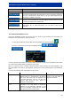
8.1.2.2 3D object types
Alpine Navigation Software supports the following 3D object types:
Type Description
3D landmarks Landmarks are 3D artistic or block representations of prominent or well-
known
objects. 3D landmarks are only available in selected cities and countries.
Elevation model Hills and mountains are shown in the background of the 3D map view
, and
illustrated by colour on the 2D map.
Elevated roads
Complex intersections and vertically isolated roads (such as overpasses or
bridges) are displayed in 3D.
3D buildings Full 3D
city building data that represents actual building size and position on the
map.
Building data is limited to the city centres of major cities in the US and
Europe.
3D terrain 3D terrain map data shows changes in terr
ain, elevations or depressions in the
land when you view the map, and use it to plot the route map in 3D
when you
navigate.
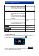
To fine-tune 3D visualisation on the map, tap the following buttons: , ,
, .