
User's Manual


69
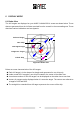
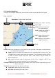
6.2 Coastline Map Mode
To switch into Coastline Map Mode, press the DISP button on the right side of the panel.
Date: yy/mm/dd
GPS Status: Position Fixed / Non-fixed
UTC: (hour : minute : second)
LAT / LON
SOG: Speed over ground of
the selected target
COG: Course over ground of
the selected target
RNG: Range of the selected
target to own ship
BRG: Bearing of the selected
target to own ship
Scale
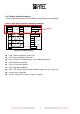
Zoom / Pan: Press and hold the <ESC> button on the right side of the panel to switch between
Pan Mode and Zoom Mode.
Zoom: Scale up and down the scale ratio of the Coastline Map. Use the <UP> and
<DOWN> keys to zoom in and zoom out the plotter. The scale ratios are from 0.05nm
to 24nm. To select a target ship, press <LEFT> and <RIGHT> keys to choose the
desired target ship.
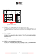
Pan: Move the plotter under the Pan Mode. Use the <UP>, <DOWN>, <LEFT> and
<RIGHT> keys to move the plotter up, down, left and right.
Centralize own ship: In both Zoom and Pan Mode, press <ESC> button to centralize your own
ship in the plotter.
Timezone: Show the Local time and the UTC time.
Local time: indicated by the color of black.
UTC time: indicated by the color of blue.