
User's Manual


51
4.3.5 Block 5: Ship Details Information
This area shows the dynamic and static of the target ship, and GPS satellite status.
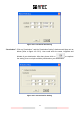
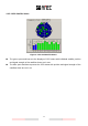
4.3.5.1 Dynamic Data
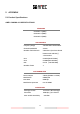
Figure 4-3-5-1 Dynamic Data
MMSI: Maritime Mobile Service Identity of the target ship.
Nav. Status: Navigational status of the target ship.
ROT: Rate Of Turn.
Heading: The direction of the target ship‟s stem.
SOG: Speed Over Ground.
COG: Course Over Ground.
Longitude: Current Longitude of target ship.
Latitude: Current Latitude of target ship.
Range: Range between the selected target and own ship.
Bearing: The related position between own ship and target ship. The unit of bearing is
degree(°).
CPA: Distance of Closest Point of Approach between own ship and target ship.
TCPA: Time to Closest Point of Approach between own ship and target ship.
Pos. Accu.: Position Accuracy; related to the GPS device used.
Received Time: The latest received time of the target ship.