
User's Manual


40
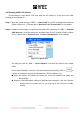
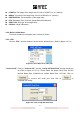
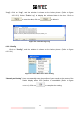
4.3.1.2 Alphanumeric View
Under this mode, all ship details will be displayed alphanumerically. To browse the entire
information, please use the bar on the screen to help locating the desired data. (Refer to Figure
4-3-1-2)
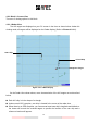
Figure 4-3-1-2 Main Display
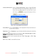
MMSI: Marine Mobile Service Identity.
CLASS: AIS Message class type:
[A]:Class A AIS,
[B]: Class B AIS,
[Base]: Base Station,
[AtoN]: Aids to Navigation,
[N/A]: Unknown.
NAME: Ship Name.
CALL SIGN: Ship‟s Call Sign.
RANGE: The distance between target ships to own ship. The unit of range is “nm” (Nautical
Mile).
BEARING: The relative angle between target ship and own ship.
SOG: Speed Over Ground, the unit of SOG is “kn” (knot).
COG: Course Over Ground.
HEADING: The heading of the target ship.
CPA: Distance to Closest Point of Approach, the unit of CPA is “nm” (Nautical Miles)
TCPA: Time to Closest Point of Approach, the unit of TCPA is “min” (Minutes).
LON: Longitude of the target ship.
LAT: Latitude of the target ship.
ROT: Rate Of Turn.