
User's Manual


39
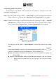
A maximum number of 500 AIS targets can be displayed on the radar plotter at a time.
The straight line extended from AIS target represents the course of the ship.
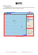
Under the situation of NO GPS data input, double click at any position on the Radar display
to make it the center. Please refer to Section 4.3. “Center View” to return to the mode of
your own ship as the center.
*NOTE: Own ship position will be fixed at the center of the Radar display WITH GPS data input.
Please use the scale to change the scale setting at the lower right corner if needed. The
scales are 800, 400, 200, 96, 48, 24, 12, 6, 3, 1.5, 0.75, 0.5, 0.25, 0.125 and 0.05 (nm).
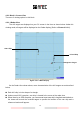
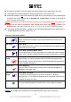
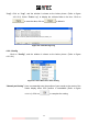
AIS target symbol description: Symbol for each AIS target displayed on the radar plotter is
as described below (refer to Table 4-3-1-1).
Own Ship
GPS Reception: Normal / Color: Blue
Under normal GPS reception, own ship is located in the center of the
radar view.
AIS Target
Color: Blue
Ship equipped with AIS system in the surrounding sea will appear on the
radar view as an AIS target.
Selected Target
Color: Blue / Flashing Black Frame
Use the arrow keys to select any target on the radar view. After selected,
press <ENT> and the detailed information on each target can be viewed.
Dangerous
Target
Color: Red / Circled Frame
When distance to a ship is smaller than CPA/TCPA, the target will be
circled in RED. Use the arrow keys to select the dangerous target and to
view its detailed information.
Friend Ship
Color: Magenta
If any pre-stored Friend Ship is nearby, the Friend Ship will appear in
Magenta on the radar view.
Lost Signal
Target
Color: Blue / Crossed
If reception of an AIS target is lost over 10 minutes, a “X” will be
displayed over it. The target will disappear from the Radar View when its
reception is lost for one hour.
AtoN
Color: Green / Spot
The icon will be displayed if any AtoN AIS is in the range of reception.
*NOTE: The straight line extended from AIS target represents the course of the ship.
Table 4-3-1-1 AIS target symbol