
User's Manual


7
1 System Overview
1.1 Product Description
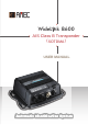
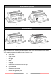
WideLink B600 is an SOTDMA AIS class B, the next evolution of AIS technology. Its 5W
transmit power, higher reporting rate and professional grade time division management
make B600 an overall more advanced product compared to AIS class B based on
CSTDMA scheme.
Its enhanced housing with IPx7 waterproof and shock and temperature robustness is
ideal to survive harsh marine environments. Chart plotter and PC can be easily
integrated over its NMEA 2000, NMEA 0183 and waterproof USB port. Its integrated
micro SD card can record AIS data and make firmware upgrade in the most intuitive
way.
The WideLink B600 converts NMEA 2000 instrument data into NMEA 0183 sentences,
such as heading, speed, depth, temperature, wind, pressure and so on. With the
multiplexing function, sensor data along with AIS and GPS information can be displayed
on chart plotters and PC programs. Its internal GNSS receiver with 72 channels supports
GPS and GLONASS by default and optional BeiDou and Galileo.
The integrated high-performance Wi-Fi (WideLink B600W only) together with AMEC AIS
App makes your favorite smartphone or tablet a real-time AIS position plotter.
The built-in splitter (WideLink B600S only) featuring zero insertion loss on reception
path and low insertion loss on transmission path ensures optimized range of your VHF
radio and AIS transponder. Its self-test function gives a simple diagnosis in the event of
antenna problem and system failure. It supports transparent mode to ensure priority to
VHF radio operation even if the splitter has power failure.