
User's Manual
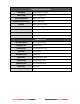

26
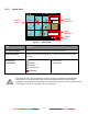
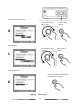
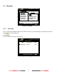
4.2.3 Radar View
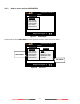
Figure 18 Radar View
Radar View displays own ship and target ships’ statuses, and their correlations.
On this view, the vertical grid lines are the longitudinal lines and the horizontal grid lines are the latitudinal
lines. Underneath the radar view is a proportional chart scale showing the current ratio displayed.
Radar View supports three ship orientation modes, North up, Head up, and Course up. Each orientation mode
is indicated by the uppercase letter (N, H, or C) on the right upper corner. The left upper corner is the north
arrow indicating the direction of north.
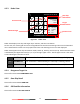
N
NORTH UP
The chart orientation is fixed and true north is always pointing up.
C
COURSE UP
The orientation is determined by the own ship’s traveling course.
H
HEAD UP
The orientation is determined by the direction of own ship’s bow.
4.2.4 Dangerous Target List
Please refer Section 4.6.7 DANGEROUS LIST
4.2.5 Own Ship Detail
Please refer Section 4.6.1 OWN SHIP
4.2.6 GPS Satellite Information
Please refer Section 4.10.6 GPS STATUS
1°13’02”N
103°48’32”E
12.00Kn
360.0°
2013/01/17 07:18:11
TX POWER LEVEL :12.5W
AMEC: 15
RNG
BRG
SOG
COG
HDG
AMEC: 15
N
12.00NM
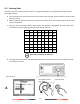
Own Ship
Own Ship
12.00Kn
N/A
0.0°
Current mode
Selected target
Own ship
information
Target
information
Function icon