
User's Manual

25
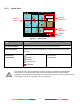
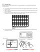
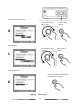
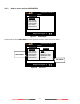
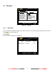
4.2.2 Coastal View
Figure 17 Coastal View
Item
Function
Own Ship information
Own-ship information for latitude, longitude, SOG and COG
Target information
Display the target information such as range and rearing relatively to the
own ship
Function Icon
(Coastal View)
Zoom In/Out
Up/Down
Left/Right
Target Selected
SART/MOB
Function icon
(Coastal View)
The coastline map in this transponder is neither verified nor approved by Hydrographic
Authorities. It is not an Electronic Chart System and therefore should not be used for
navigation. The information provided by the coastline map is for reference only and should be
used together with other navigation sources and devices.
Targets Received :10
12.00Kn
241.0°
53°08’56”N
4°57’00”E
RNG 39.54NM
BRG +320.53°
12 NM
52°30’N
53°00’N
53°30’N
4°00’E
5°00’E
2013/01/17 07:18:11
Own Ship
information
Target
information
Function
Icon
Selected
Target