
User's Manual

94
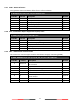
A.5.10 GLL – Geographic Position – Latitude/Longitude
Latitude and longitude of vessel position, time of position fix and status.
$--GLL, llll.ll, a, yyyyy.yy, a, hhmmss.ss, A, a *hh<CR><LF>
Field No.
Format
Description
Remark
1
llll.ll, a
Latitude, N/S
2
yyyyy.yy, a
Longitude, E/W
3
hhmmss.ss
UTC of position
4
A
Status, A=data valid V=data invalid
5
a
Mode indicator
A.5.11 GNS – GNSS Fix Data
Fix data for single or combined satellite navigation systems (GNSS). This sentence provides fix data for
GPS, GLONASS, possible future satellite systems and systems combining these.
$-- GNS, hhmmss.ss, llll.ll, a, yyyyy.yy, a, c--c,xx,x.x,x.x,x.x,x.x,x.x,a *hh<CR><LF>
Field No.
Format
Description
Remark
1
hhmmss.ss
UTC of position
2
llll.ll, a
Latitude, N/S
3
yyyyy.yy, a
Longitude, E/W
4
c--c
Mode indicator
5
xx
Total number of satellites in use
ignored
6
x.x
HDOP
ignored
7
x.x
Antenna altitude, m, re:mean-sea-level (geoid)
ignored
8
x.x
Geoidal separation, m
ignored
9
x.x
Age of differential data
ignored
10
x.x
Differential reference station ID
ignored
11
a
Nacigational status indicator
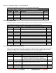
A.5.12 GSA – GNSS DOP and Active Satellites
GNSS receiver operating mode, satellites used in the navigation solution reported by the GGA or GNS
sentences, and DOP values. If only GPS, GLONASS, etc. are used for the reported position solution,
the talker ID is GP, GL, etc. and the DOP values pertain to the individual system.
$--GSA, a, x, xx,xx,xx,xx,xx,xx,xx,xx,xx,xx,xx,xx,x.x,x.x,x.x*hh<CR><LF>
Field No.
Format
Description
Remark
1
a
Mode:
M = manual, forced to operate in 2D or 3D mode
A = automatic, allowed to automatically switch 2D/3D
2
x
Mode: 1 = fix not available, 2 = 2D, 3 = 3D
3
xx,xx,xx,xx,xx,xx,
xx,xx,xx,xx,xx,xx
ID numbers of satellites used in solution
4
x.x
PDOP
5
x.x
HDOP
6
x.x
VDOP