
User`s guide


PC*MILER-AS400 User’s Guide 66
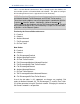
GTTLAT Sample RPG Program that converts City, Jurisdiction pairs or zip codes
to Lat/longs
GTTLATC CL program that creates output queue and starts GETLAT RPG
GTTMIL Sample RPG Program that performs point-to-point mileage lookups
GTTMILC CL program that creates output queue and starts GETMIL RPG
GTQNAMTL RPG Program that determines library and data queue name for sending
requests
VTLADR RPG Program that validates ZIP codes, place names, and street
addresses; also provides pick lists of ZIPs codes, names and addresses
when partial name, ZIP or address is passed in RPG parameters.
MIDQUE Data queue that contains input mileage lookup records
QUEUE CL program that writes to the MIDQUE request data queue
TLSEND External data structure for sending mileage requests
TLRESP External data structure for receiving mileage output
TLDRW External data structure for sending graphics requests to PC
TLSEND2 External data structure with field mappings for Borders and Use Ferry Distance
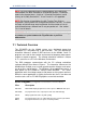
The program TOLLINQ contains two subroutines that can be used to
integrate miles with other transportation software. The subroutine SNDREQ
sends mileage requests to PC*MILER and the subroutine RSLT receives
mileage results from PC*MILER. The subroutine PLOT can be used to send
graphics requests for ETA truck display of graphics.
For example, a truck or vehicle ID’s Lat/Long, ZIP, or city name position can
be sent to the PC using PLOT and the “DT” request. Then a “DR” request
with the truck’s origin and destination can be sent so that a graphical ETA
can be determined. The data structures of these subroutines are described
below.
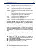
The PC Mileage Server can respond to a total of thirteen types of mileage
and graphic requests:
Mileage:
VN = Version of PC*MILER being used by the server
VA = Validation that a stop (City, ZIP code, etc.) is recognized by
PC*MILER or a list of possible matches to a partial city or ZIP code
MI = Total mileage for up to 30 stops
SM = Total mileage for up to 30 stops broken down by state or province
HS = Turn-by-turn driving instructions for up to 30 stops
LL = Returns the lat/long coordinates for a city or address
(PC*MILER|Streets only)
Graphics:
DR = Draw Route for up to 30 Stops
DT = Draw up to 30 truck bitmaps or “push pins” on the map