
Quick Reference Guide Instruction Manual


Ag Leader EZ-Guide
™
Quick Reference Card
A
CALCULATING ACREAGE
You can map area points to calculate acreage. Area points can be added in both Guidance mode and Area mode.
ALARMS
If the alarm is connected, it sounds at various times during a swathing operation to indicate that you are:
• entering or leaving the spray zone (as defined by the A-B end-zone, or by a defined headlands area)
• drifting too far off-swath (use the
XTE WARN option to configure this)
• returning to the current swath while guidance is paused
• losing differential corrections (use the
DIFF GPS option to configure this)
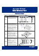
New Area Calculate Area View Area
1. To clear all
area points in
preparation
for a new field, at any time
press:
2. To toggle between
CONFIRM or
CANCEL, press:
3. When the desired
option is displayed,
press:
• To calculate the area of your field drive to each
corner of the field and press:
Each time the key is pressed, a new area value
is displayed. The area is calculated from the outside
end of the application boom.
Note – A minimum of three area points are required to
calculate the field area. The maximum number of area
points is 99.
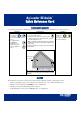
The following diagram shows mapped area points and the
area calculated.
Tip – Acreage calculations take the current swath width
into account, so you should drive a half-swath in from the
field edge.
• To view the
field area at
any time,
press the following buttons until
the area is displayed:
+
Adjusted area is calculated
Actual swath
pass width
at the outside of the swath pass
+