
User manual


Aerosoft Santorini X 1.00
Page 5
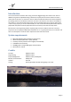
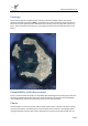
Coverage
This scenery covers the complete Santorini island group with all villages and the main airport
(Santorini Thira National airport, LGSR) in great detail. This scenery shows the island in the hot dry
late summer season (because that’s what most tourists know). So do not expect island to be very
green. The main platform of the airport is a very light concrete that will show almost white in this
season.
Compatibility with other scenery
As far as we have tested this product is compatible with all existing scenery covering the same area
assuming you follow information given here. Aerosoft however can only guarantee compatibility
with a standard FSX. Discuss this on the forum with us if you have questions.
Charts
The Greek state is not as easy as other nations about aviation charts. We were not able to include
any charts and there is not official online source for these charts. However a quick Google search
using the keywords Santorini airport charts will lead you to several sources that will help you out.