
User manual


Aerosoft Santorini X 1.00
Page 10
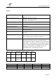
Data
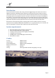
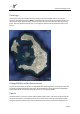
Location
Thira (Santorini), Cyclades Prefecture, South Aegean Sea
ARP co-ordinates and site at AD
36.399169 360 23' 57.01" North
25.479333 0250 28' 45.60" East
Major Town serviced
Fira at 7 Km
Elevation
127 feet (39 meters)
MAG VAR / annual change
003° E (2010)
Use
Aerodrome available for national and international civil air traffic
with all types of aircraft,
Information
TOWER 118.05,
APP 118.05
Acceptable types
B-757-200, B-737-800, B-737-300/-400/-500,
A-321, A-320, Avro RJ-100, Fokker 70, ATR-42/-72
Scheduled flights
Olympic Airlines, Aegean Airlines, Athensairways, Corsair,
Aero Lloyd, Finnair, Austrian Airlines, Brittania Airways
Sweden, Maersk Air, Sobelair, Braathens, Deutsche BA, Novair
- Nova Airlines, CSA Czech Airlines, SAS - Scandinavian Airlines
System, Transavia, Livingston Energy Flight, Eurofly, Martinair,
Edelweiss Air, Adria Airways, Excel Airways, Azzurra Air,
Thomas Cook Airlines, Air Scandic International
Rwy
True °
Dimensions
Surface
Lights
PAPI
34R/16L
339°/159°
6972x98 ft
2125x30 m
Asphalt
SF, REIL
A1
Left
03%
34L/16R
159°/339°
6972x98 ft
2125x30 m
Asphalt
SF, REIL
A1
Left
03%
System
ID
Channel
Type
Freq
Terminal VOR/DME
SNI
041X
DVOR/DME
110.4
LOCATOR
THR
-
NDB
307
TACAN
SAN
111X
-
116.4