
Documentation


LGSM – Samos | 29palms.de | 29palms-store.de
4 | P a g e
Runway Lights:
Samos runway has some conventional runway edge and end lights.
There is an approach lights system (ALS) for runway 09 which has worn in time and is partially visible
in the real airport due to wear and vegetation grown around it. This is reflected in the scenery.
You can spot it in the Challenger 300 dusk approach 09 video documented below.
Even though the official charts of Samos indicate one set of PAPI4 lights on each runway's side, the
actual configuration in the real airport is of four sets of APAPI2 (abbreviated PAPI) lights left and
right of each touch down zone for runways 09 and 27. This is how the real airport is, this is how we
did it. The four sets of APAPI lights provide greater accuracy for descent path and redundancy (in
real airport) in case a light bulb needs replacement.
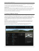
Samos LGSM charts publicly available with Login at Greece AIP
The charts can be found in the following folder: “[FS main directory]/29Palms/29Palms – User Documents”
4. Airport Operations
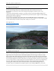
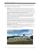
The airport is situated in a basin by the sea surrounded by rising terrain close by in three quadrants
with only one direction available for approach and departure, that being from the south. The east-
west oriented runway is at sea level, but 2,044m (6,706 ft) long. This is something which provides
little room for error in the procedures explained below.
The usual wind prevails from northwest (310~340) and anything above 10kts generates turbulence
and/or windshear on approach from surrounding terrain. Stronger winds always become gusty and
a typical METAR of Samos with the summer "Meltemi" wind of Aegean Sea will display 33015G25KT.
To complicate issues more there is a hill (Pythagoreion) just east of the airport north abeam of the
final approach to runway 27. This hill generates prohibitive gusts and wind shear at lower levels in
conditions anything above 10~15kts for aircraft who may be low and slow on approach runway 27.
To complicate issues even more, just 4nm east of threshold 27 lies the coast of Turkey with steep
rising barren terrain. This close proximity also means that Samos approach ATC can provide services
only up to 2nm southeast from the runway with standard ICAO aircraft separation not guaranteed.
There are often cases where “fast and low” flying aircraft “groups in formation” pass just 3nm south
abeam the airport – typically outside Greece’s FIR border – without prior notice/coordination from
neighboring ATC facilities. For more background on this read
here: https://en.wikipedia.org/wiki/Aegean_dispute
Samos does not have approach radar and all ATC is based on procedural separation in relation to
time above SAM VOR Initial Approach Fix (IAF) or DELOX IAF.
As IFR the airport is approached:
a) from the west via a DME ARC on SAM VOR using DELOX point as IAF
or
b) from above using SAM VOR as IAF with a teardrop procedure to the south
As VFR there are recommended VFR routes which you can see in the charts in the following folder:
“[FS main directory]/29Palms/29Palms – User Documents”