
User manual
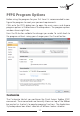
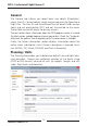
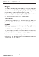
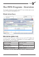

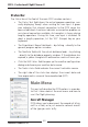
Table Of Contents

18 19
• Click the Wind button to enable the wind vectors at the flight
planned altitudes for the shown height, date and time. When
using online weather you are able to see a trend for the next
hours by moving the control pusher.
• The Adequate Airports icon will display threshold distance and
ETOPS circles if an ETOPS flight is planned.
Weather & NOTAMs
The Weather & NOTAMs window allows you either to enter, to search
for or to display automatically airport and FIR information.
• Click onto the Weather tab to get weather details for the se-
lected identifiers.
• Click onto the NOTAMs tab to get detailed NOTAMs information
for the selected identifiers.
• You are now able to print and save your Weather & NOTAMs
information.
Tracks (Organized Tracks System)
The Tracks window displays textual information about the following Or-
ganized Tracks Systems:
• North Atlantic Tracks (NATs)
• Pacific Tracks (PACOTs)
• Australian Tracks (AUSOTS)
Scratchpad
The Scratchpad window enables you to take notes or save important
information for the dispatchers use. You are able to print, save, copy,
paste or delete the shown information.