
User manual

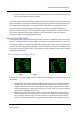
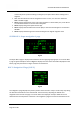


Table Of Contents
- PBY Catalina
- Introduction
- System requirements
- Credits
- Copyrights
- Contact support
- Models and versions
- Limitations
- Failure model and special features
- Aerosoft Sound Control
- Flight model
- Using the switches and knobs
- Interactive Checklist
- Avionics, 1940’s military cockpit
- Avionics, modern cockpit
- Engine Settings
- Mission
- Appendix A: Simplified checklist
- Appendix B: KX 165A TSO
- Appendix C: KLN-90B User Manual
- INTRODUCTION
- OVERVIEW
- DEFINITIONS:
- SYSTEM USE
- NAV: NAVIGATION PAGES
- CALC: CALCULATOR PAGES
- STAT: STATUS PAGES
- SETUP: SETUP PAGES
- OTHER: OTHER PAGES
- TRIP: TRIP PLANNING PAGES
- MOD: MODE PAGES
- FPL: FLIGHT PLAN PAGE
- NAV: NAVIGATION PAGES (right screen)
- APT: AIRPORT PAGES
- NEAREST Airport Pages
- VOR: VOR Page
- NDB: NDB Page
- INT: INTERSECTION PAGE
- SUPL: SUPPLEMENTAL PAGE (SUP)
- CTR: CENTER WAYPOINT PAGE
- REF: REFERENCE WAYPOINT PAGE
- ACTV: ACTIVE WAYPOINT PAGE (ACT)
- D/T: DISTANCE/TIME PAGES
- MESSAGE PAGE
- DIRECT-TO PAGE

Aerosoft PBY Catalina 1.00 Manual
Page 46 of 100
when the aircraft levels off at the designated altitude, you will be at the height and distance from
the active waypoint you set earlier.
Examples of the vertical navigation page are shown in Figs 1.6-1.9 above. The information presented
in line 1 of Figs 1.7 and 1.8 is not displayed when in the time mode. The meaning of each line of this
page is discussed below.
• Line 1: The information displayed on the right of this line changes according to the state of
vertical navigation. The VNV annunciation on the left indicates you are on the vertical
navigation page, and is always displayed when on this page. Fig1.6 shows the display when
vertical navigation is off. INACT is annunciated to indicate vertical navigation is inactive.
Fig1.7 shows the display when vertical navigation is on and you are more than 10 minutes
from the determined ascent or descent point. If you are between 0 and 10 minutes from the
point, line 1 will appear as shown in Fig1.8. Fig1.9 shows this line as it is displayed when you
are ascending or descending, with the advisory altitude on the far right.
• Line 2: Display of the indicated altitude in feet above MSL. Match this value to the advisory
altitude during ascent or descent by changing the vertical speed value on the KAS 297C pre-
altitude selector.
• Line 3: Displays the height above MSL of the point in space you are defining. Enter the
desired value by going to the NAV 4 page, clicking on the cursor button, using the outer
knob to change data entry fields, and changing the values with the inner knob. The altitude
value increments/decrements in units of 100.
• Line 4: Displays the distance from the next active waypoint to the point in space you are
defining. Enter the desired value by going to the NAV 4 page, clicking on the cursor button,
using the outer knob to change data entry fields, and changing the values with the inner
knob. The distance value increments/decrements in units of 10 and 1 to a maximum of 99.
The next active waypoint identity is displayed on the left side of the line. The "-" sign
displayed to the immediate left of the entered number indicates you are in the descend
mode of vertical navigation. It is replaced by a "+" sign when in the ascending mode.
• Line 5: Displays the angle of the aircraft flight path used to ascend or descend to the chosen
point in space. When in the immediate descend mode this value is not changed by the user,
and the current angle will be displayed throughout the descent. The value increases as you
get nearer to the next active waypoint. If in the vertical navigation delay mode the angle
value is set by the user and is the angle the unit uses to determine the advisory altitude. The
"-" sign displayed to the immediate left of the entered number indicates you are in the
descend mode of vertical navigation. It is replaced by a "+" sign when in the ascending
mode. To determine the vertical speed in feet per minute for a given angle, go to the CAL 4
page and use the program to calculate the fpm from the angle and the airspeed. When
entering the airspeed on that page, however, remember the desired airspeed is the speed to
be used during the descent and not necessarily the current airspeed.
There are several ways to use the vertical navigation feature. One way is to begin to ascend or
descend from the current location at the vertical speed dictated by the displayed angle. The angle
displayed at this time is the angle the unit has determined will take you from your current location,
at your current airspeed to the defined point in space.