
User manual

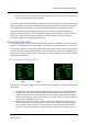
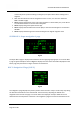


Table Of Contents
- PBY Catalina
- Introduction
- System requirements
- Credits
- Copyrights
- Contact support
- Models and versions
- Limitations
- Failure model and special features
- Aerosoft Sound Control
- Flight model
- Using the switches and knobs
- Interactive Checklist
- Avionics, 1940’s military cockpit
- Avionics, modern cockpit
- Engine Settings
- Mission
- Appendix A: Simplified checklist
- Appendix B: KX 165A TSO
- Appendix C: KLN-90B User Manual
- INTRODUCTION
- OVERVIEW
- DEFINITIONS:
- SYSTEM USE
- NAV: NAVIGATION PAGES
- CALC: CALCULATOR PAGES
- STAT: STATUS PAGES
- SETUP: SETUP PAGES
- OTHER: OTHER PAGES
- TRIP: TRIP PLANNING PAGES
- MOD: MODE PAGES
- FPL: FLIGHT PLAN PAGE
- NAV: NAVIGATION PAGES (right screen)
- APT: AIRPORT PAGES
- NEAREST Airport Pages
- VOR: VOR Page
- NDB: NDB Page
- INT: INTERSECTION PAGE
- SUPL: SUPPLEMENTAL PAGE (SUP)
- CTR: CENTER WAYPOINT PAGE
- REF: REFERENCE WAYPOINT PAGE
- ACTV: ACTIVE WAYPOINT PAGE (ACT)
- D/T: DISTANCE/TIME PAGES
- MESSAGE PAGE
- DIRECT-TO PAGE

Aerosoft PBY Catalina 1.00 Manual
Page 45 of 100
NAV 4: Navigation 2 Page (NAV 4)
Fig 1.6 Fig 1.7
Fig 1.8 Fig 1.9
The navigation 4 page is used to enter the parameters used by the unit to compute ascending or
descending paths in the vertical navigation mode (VNV). This page interfaces with the autopilot, and
usually the autopilot altitude hold function is used during vertical navigation. There are 5 lines of
information on this page; the last 3 lines are changed by the user during vertical navigation. There
are two ways to use the vertical navigation feature. One way is to begin an ascent or descent from
the current location and another is to begin at a later time and place. Both ways are discussed
below. The NAV 4 page can be displayed on either the left or right display screens, or simultaneously
on both.
The basic idea in this type of vertical navigation is to define a point in space before and above the
next active waypoint, defined in terms of distance from the waypoint and feet above
ground, and
then choose the vertical speed and airspeed you would like to use to get to that point. The KLN 90B
uses this information to determine an "advisory" altitude to "advise" you of the altitude you need to
be at, at any given time during VNAV, in order to arrive at the chosen point in space. Both the
indicated and advisory altitudes will increase and decrease as you ascend or descend, respectively,
and the idea is to keep the indicated altitude value matched with the advisory altitude value during
the descent. Note that the advisory altitude changes according to the entered vertical speed and
airspeed values, which are usually not the true, exact values. The values should remain close,
however if they do not, the vertical speed can be adjusted to get them to match. If they are matched