
User manual

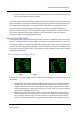
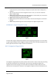


Table Of Contents
- PBY Catalina
- Introduction
- System requirements
- Credits
- Copyrights
- Contact support
- Models and versions
- Limitations
- Failure model and special features
- Aerosoft Sound Control
- Flight model
- Using the switches and knobs
- Interactive Checklist
- Avionics, 1940’s military cockpit
- Avionics, modern cockpit
- Engine Settings
- Mission
- Appendix A: Simplified checklist
- Appendix B: KX 165A TSO
- Appendix C: KLN-90B User Manual
- INTRODUCTION
- OVERVIEW
- DEFINITIONS:
- SYSTEM USE
- NAV: NAVIGATION PAGES
- CALC: CALCULATOR PAGES
- STAT: STATUS PAGES
- SETUP: SETUP PAGES
- OTHER: OTHER PAGES
- TRIP: TRIP PLANNING PAGES
- MOD: MODE PAGES
- FPL: FLIGHT PLAN PAGE
- NAV: NAVIGATION PAGES (right screen)
- APT: AIRPORT PAGES
- NEAREST Airport Pages
- VOR: VOR Page
- NDB: NDB Page
- INT: INTERSECTION PAGE
- SUPL: SUPPLEMENTAL PAGE (SUP)
- CTR: CENTER WAYPOINT PAGE
- REF: REFERENCE WAYPOINT PAGE
- ACTV: ACTIVE WAYPOINT PAGE (ACT)
- D/T: DISTANCE/TIME PAGES
- MESSAGE PAGE
- DIRECT-TO PAGE

Aerosoft PBY Catalina 1.00 Manual
Page 44 of 100
example of this page is shown in Fig 1.4. Listed below is a description of the different lines of
information.
• Line 1: Display to indicate the information referring to the present position of the aircraft.
• Line 2: Display listing the nearest VOR to the current aircraft position. The VOR identifier
code is shown on the left. The next display to the right is the magnetic north degrees to or
from the VOR, with an annunciation to show the direction from the VOR.
• Line 3: Display listing the distance to the VOR in nm.
• Line 4: Display showing the present latitude of the aircraft.
• Line 5: Display showing the present longitude of the aircraft.
NAV 3: Navigation 3 Page (NAV 3)
Fig 1.5
The navigation 3 page is shown in Fig 1.5. This page has 6 lines of information which are discussed
below.
• Line 1: The display on this line is exactly the same as the NAV 1 page line 1 display. The
annunciation shown in the above figure shows the display when in the Direct-To mode.
• Line 2: Displays the desired track to the active waypoint in degrees magnetic north.
• Line 3: Displays the aircrafts current track over the ground in degrees magnetic north.
• Line 4: Displays the cross track error correction in nm. The number lists the distance from
the desired track, and the arrow indicates which way the aircraft needs to fly to get back on
track.
• Line 5: Displays the minimum safe altitude. For this aircraft (not the real one) the MSA is
defined as the indicated altitude of the aircraft plus 1000 feet when the aircraft is below
5000 ft AGL, and plus 2000 feet when above this altitude.
• Line 6: Displays the minimum enroute safe altitude. Not functional in this unit.