
User manual

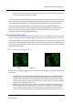
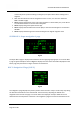


Table Of Contents
- PBY Catalina
- Introduction
- System requirements
- Credits
- Copyrights
- Contact support
- Models and versions
- Limitations
- Failure model and special features
- Aerosoft Sound Control
- Flight model
- Using the switches and knobs
- Interactive Checklist
- Avionics, 1940’s military cockpit
- Avionics, modern cockpit
- Engine Settings
- Mission
- Appendix A: Simplified checklist
- Appendix B: KX 165A TSO
- Appendix C: KLN-90B User Manual
- INTRODUCTION
- OVERVIEW
- DEFINITIONS:
- SYSTEM USE
- NAV: NAVIGATION PAGES
- CALC: CALCULATOR PAGES
- STAT: STATUS PAGES
- SETUP: SETUP PAGES
- OTHER: OTHER PAGES
- TRIP: TRIP PLANNING PAGES
- MOD: MODE PAGES
- FPL: FLIGHT PLAN PAGE
- NAV: NAVIGATION PAGES (right screen)
- APT: AIRPORT PAGES
- NEAREST Airport Pages
- VOR: VOR Page
- NDB: NDB Page
- INT: INTERSECTION PAGE
- SUPL: SUPPLEMENTAL PAGE (SUP)
- CTR: CENTER WAYPOINT PAGE
- REF: REFERENCE WAYPOINT PAGE
- ACTV: ACTIVE WAYPOINT PAGE (ACT)
- D/T: DISTANCE/TIME PAGES
- MESSAGE PAGE
- DIRECT-TO PAGE

Aerosoft PBY Catalina 1.00 Manual
Page 43 of 100
of the scale points up when tracking to a waypoint, and points down when tracking from a
waypoint.
• Note: the CDI scale factor can be changed from 5 nm to 1 nm, or to 0.2 nm in either the
MOD 1 or MOD 2 page.
• Line 3: Displays the distance to the next active waypoint in nautical miles (nm). In the Direct-
To mode the destination is the next active waypoint.
• Line 4: Displays the ground speed in knots (kt).
• Line 5: Displays the estimated time enroute (ETE) to the next active waypoint. The format is
HH:MM.
• Line 6: Displays the bearing to the next active waypoint in degrees magnetic north.
SUPER NAV 1: Super navigation 1 page
Fig 1.3
The Super NAV 1 page is displayed when both the left and right page type groups are set to the NAV
1 page. A typical example is shown in Fig 1.3. It displays the exact same information displayed on the
NAV 1 page, but presented in a larger and easier to read format.
NAV 2: Navigation 2 Page (NAV 2)
Fig 1.4
The navigation 2 page displays the present position of the aircraft in 2 ways. The first way is by listing
the direction and distance to the nearest VOR. The second way is by listing the latitude and
longitude of the aircraft. This page is set as the left screen display at startup to allow the user to
determine the aircraft position at that time. The navigation 2 page has 5 lines of information and an