
User manual


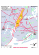
Table Of Contents
- Index
- Introduction
- Copyrights
- Credits
- System requirements
- Contact support
- How realistic is Manhattan Scenery?
- Area covered
- Included
- Season
- Framerates
- Water textures
- Settings
- Flying over this scenery in a light aircraft
- Helicopters over Manhattan
- KRJB, Port Authority Downtown Manhattan/Wall Street Heliport
- 6N5, East 34 Street Heliport
- KJRA, West 30 Street Heliport
- 6N4, Pan Am Metroport Heliport
- Mission: Manhattan Tour
- Charts

Manhattan X 1.00
Page 19 of 19
Charts
In an environment as complex as Manhattan there are special routes for light aircraft
and helicopters. As you will see most routes are either over water or over major
highways. This simplifies navigation and prevents noise complaints. Some routes are
one way only, others can be used in two directions. If you are on a two-way route,
stick to your correct altitude and if possible stay slightly to the right of the road you
are following.
The charts were made by Konrad Cissowski (www.customdigitalmaps.com
)