
User manual


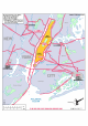
Table Of Contents
- Index
- Introduction
- Copyrights
- Credits
- System requirements
- Contact support
- How realistic is Manhattan Scenery?
- Area covered
- Included
- Season
- Framerates
- Water textures
- Settings
- Flying over this scenery in a light aircraft
- Helicopters over Manhattan
- KRJB, Port Authority Downtown Manhattan/Wall Street Heliport
- 6N5, East 34 Street Heliport
- KJRA, West 30 Street Heliport
- 6N4, Pan Am Metroport Heliport
- Mission: Manhattan Tour
- Charts

Manhattan X 1.00
Page 18 of 19
Mission: Manhattan Tour
There are several operators who fly helicopter tours around Manhattan and they are
really fun but rather expensive. For the tour we fly in this mission you should expect
to pay around $200 plus a bit for airport tax etc. It’s one of the best tours, however,
as it goes round the southern tip of Manhattan and includes all the best known
sights including the Statue of Liberty. There are no points to gain or times to beat,
you just fly it as you like as long as you fly over each of the waypoints that are
shown on the screen. Stay at around 500 feet and when you are not a great
helicopter pilot, make sure you put the realism at the lowest level. Believe us when
we tell you that the highest realism levels might work well for aircraft but make
helicopters unstable in FSX.
You start on pad 9 of Wall Street heliport
(and you will end on this pad as well). The
whole mission will be guided by voice: in
fact you will hear yourself speak. Just follow
your own instructions. In order to start up
your helicopter use the default [Control]-[E]
command. In order to shut it down use
[Control]-[Shift]-[F1] which will close the
fuel flow.
If you want to see where you are going it
will help you to activate ‘Show captioning’
in the SETTING – GENERAL dialog. This will
show the well-known green arrows to the next waypoint in the mission.
You will find the mission in the Missions dialog under Aerosoft Flights.
The route of the mission is shown as a thin magenta line on top of the Manhattan
Helicopter chart.