
User manual


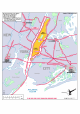
Table Of Contents
- Index
- Introduction
- Copyrights
- Credits
- System requirements
- Contact support
- How realistic is Manhattan Scenery?
- Area covered
- Included
- Season
- Framerates
- Water textures
- Settings
- Flying over this scenery in a light aircraft
- Helicopters over Manhattan
- KRJB, Port Authority Downtown Manhattan/Wall Street Heliport
- 6N5, East 34 Street Heliport
- KJRA, West 30 Street Heliport
- 6N4, Pan Am Metroport Heliport
- Mission: Manhattan Tour
- Charts

Manhattan X 1.00
Page 13 of 19
Runway Information
Helipad H1
Dimensions: 62 x 62 ft. / 19 x 19 m
Surface: concrete, in good condition
Weight limitations: Single wheel: 50000 lbs
Runway edge lights: PERI
Traffic pattern: left left
Markings: basic, in good condition
Additional Remarks
• NO FLIGHTS OR APPROACHES OVER FDR DRIVE;
• TWO-WAY RADIO REQUIRED.
• BIRDS ON AND CLOSE TO HELIPORT.
• BOATS MAY NAVIGATE IN WATER ALONG HELIPORT PIER.
• 100 FT CRANES OPERATING NEAR USCG FERRY SLIP.
• 12 HELICOPTER PARKING SPACES WITH ADDITIONAL TRANSIENT
POSITIONS AVAILABLE
• FIRE PROTECTION FOAM SYSTEM ON SITE.
6N5, East 34 Street Heliport
In operation since 1970 this is a highly efficient heliport in an ideal Midtown location
and mostly in use for public officials, emergency transports and news media. With 5
helipads it is the smallest of the Manhattan heliports but it is the most efficient one.
FAA Identifier: 6N5
Lat/Long: 40-44-33.366N / 073-58-19.499W
Elevation: 10 ft. / 3 m (estimated)
Variation: 13W (1985)
Attendance: MON-FRI 0800-2000
Wind indicator: yes
Segmented circle: no
Lights: DUSK-DAWN
BCN LCTD ABOVE OFFICE TRAILER BLO ELEVATED HIGHWAY.
Beacon: white-green-yellow (heliport)
Landing fee: yes
Heliport Communications
CTAF/UNICOM: 123.075