
User manual
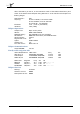
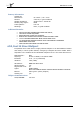
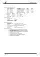


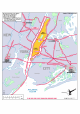
Table Of Contents
- Index
- Introduction
- Copyrights
- Credits
- System requirements
- Contact support
- How realistic is Manhattan Scenery?
- Area covered
- Included
- Season
- Framerates
- Water textures
- Settings
- Flying over this scenery in a light aircraft
- Helicopters over Manhattan
- KRJB, Port Authority Downtown Manhattan/Wall Street Heliport
- 6N5, East 34 Street Heliport
- KJRA, West 30 Street Heliport
- 6N4, Pan Am Metroport Heliport
- Mission: Manhattan Tour
- Charts

Manhattan X 1.00
Page 12 of 19
above the Battery on Pier 6, on the East River north of the Staten Island Ferry and
south of the South Street Seaport along FDR Drive. It can handle 12 helicopters on
floating barges.
FAA Identifier: JRB
Lat/Long: 40-42-04.369N / 074-00-32.502W
40-42.07282N / 074-00.54170W
40.7012136 / -74.0090283
Elevation: 12 ft. / 3.60 m (estimated)
Variation: 13W (1985)
Heliport Operations
Heliport use: Open to the public
ARTCC: NEW YORK CENTER
NOTAMs facility: ISP (NOTAM-D service available)
Attendance: MON-FRI 0700-1900, SAT-SUN ON CALL
Wind indicator: lighted
Segmented circle: no
Lights: DUSK-DAWN
Landing fee: yes
Fire and rescue: ARFF index A
Heliport Communications
CTAF/UNICOM: 123.05
Nearby radio navigation aids
VOR radial/distance VOR name Freq Var
CRIr327/7.5 CANARSIE VOR/DME 112.30 11W
LGAr244/8.1 LA GUARDIA VOR/DME 113.10 12W
TEBr176/9.2 TETERBORO VOR/DME 108.40 11W
NDB name Hdg/Dist Freq Var ID
BRIDGE 336/9.8 414 12W OGY --- --. -.--
CONDA 320/11.7 373 14W JF .--- ..-.
PATERSON 168/16.1 347 12W PNJ .--. -. .---
Heliport Services
Parking: tiedowns
Airframe service: NONE
Powerplant service: NONE