Manhattan X
Manhattan X 1.00 Index Index ......................................................................................................................................................................... 2 Introduction............................................................................................................................................................... 3 Copyrights .............................................................................................................................
Manhattan X 1.00 Introduction When we released Manhattan for FS2004 it was a controversial release. Clearly it showed a very high definition scenery but it was slow, (even too slow for some), on the hardware many simmers had at that time. (We do not expect this new version to be different btw.) But in the end it was an unbridled success as hardware started to catch up and it became our best selling scenery product, both in download as well as in boxed format.
Manhattan X 1.00 Credits Concept: Programming: Additional modeling: Project Management: Manual, documentation: Manual corrections: Maps& Charts Installer: Mission: Mission Voices: Testing: Mathijs Kok, Andras Kozma Andras Kozma Peter Orosz and Richard Kozma Mathijs Kok Mathijs Kok Christoph Beck Konrad Cissowski (www.customdigitalmaps.com) Andreas Mügge Raphael Jakob Paul R. Laube, William Lennox Several good folks who will all be getting a free copy.
Manhattan X 1.00 How realistic is Manhattan Scenery? Well, actually it is not realistic at all. How about that for an answer? But it is true. How can you simulate something as complex as Manhattan? Even doing just one building to a good degree of detail would slow your system down to a slideshow and would take us months to do. This product is an impression of Manhattan. We believe it is as accurate as possible given the hardware limitations and commercial limitations.
Manhattan X 1.00 Season For some reason Microsoft decided that half the world is covered with snow in winter time and New York is in the zone that has 3 months of snow in FSX. We think this is not very realistic and did not include snow textures. The scenery looks best in summer season.
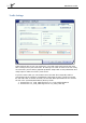
Manhattan X 1.00 Settings As always there are certain settings that make the scenery work best. They are explained below. Graphics Settings Here the Global texture resolution is important. It needs to be on Very High to show all textures and the Target frame rate is best left unlimited. If you can use the Preview DX10 mode we suggest you try it since it’s probably faster and certainly looks a bit better.
Manhattan X 1.00 Scenery Settings In the Scenery Display Settings dialog we advise you to set the scenery complexity at Extremely dense, Ground scenery shadows to Off and Texture resolution at 60 cm. Although the water effects of FSX are stunning they simply do not work well in this environment (and also reduce frame rates tremendously). Set them to a very low setting to have the water look more realistic. Autogen density can be varied and should be as high as you can afford.
Manhattan X 1.00 Traffic Settings Traffic settings are at your own preference. The road traffic looks superb but does take a heavy toll on your frame rate. At settings over 75% we have even seen many out of memory errors and/or graphical problems. Ship traffic is less problematic and really helps to make the scenery come to life. If you like more traffic you can rename two of the BGL files. Originally traffic is concentrated at the outskirts of Manhattan (and bigger streets).
Manhattan X 1.00 Flying over this scenery in a light aircraft We will describe two routes: one from North/East to South/West and one the other way around. These route descriptions lean heavily on a published document from Carney Aviation. A map is provided for these routes. General Always use the frequency 123.05 to announce yourself on the Hudson River and 123.075 on the East River. Turn on every light you have and stick to the correct side of the river at or below 1100 ASL. Do not exceed 140 knots.
Manhattan X 1.00 When you get your clearance to enter Class B airspace, you will probably be asked to fly over Central Park, the North Tip of Roosevelt Island (between Manhattan and Queens), the Tower Cab, and the South end of Throgs Neck Bridge. This keeps you clear of arrivals and departures on LGA's runway 4/22. A chart showing the route is added at the end of the manual.
Manhattan X 1.00 above the Battery on Pier 6, on the East River north of the Staten Island Ferry and south of the South Street Seaport along FDR Drive. It can handle 12 helicopters on floating barges. FAA Identifier: Lat/Long: Elevation: Variation: JRB 40-42-04.369N / 074-00-32.502W 40-42.07282N / 074-00.54170W 40.7012136 / -74.0090283 12 ft. / 3.
Manhattan X 1.00 Runway Information Helipad H1 Dimensions: Surface: Weight limitations: Runway edge lights: Traffic pattern: Markings: 62 x 62 ft. / 19 x 19 m concrete, in good condition Single wheel: 50000 lbs PERI left left basic, in good condition Additional Remarks • • • • • • • NO FLIGHTS OR APPROACHES OVER FDR DRIVE; TWO-WAY RADIO REQUIRED. BIRDS ON AND CLOSE TO HELIPORT. BOATS MAY NAVIGATE IN WATER ALONG HELIPORT PIER. 100 FT CRANES OPERATING NEAR USCG FERRY SLIP.
Manhattan X 1.00 Nearby radio navigation aids VOR LGA TEB CRI JFK COL radial/distance r254/5.3 r158/7.6 r347/8.6 r318/11.3 r029/27.2 NDB name BRIDGE CONDA PATERSON Hdg/Dist 351/11.2 334/12.2 158/14.7 VOR name LA GUARDIA VOR/DME TETERBORO VOR/DME CANARSIE VOR/DME KENNEDY VOR/DME COLTS NECK VOR/DME Freq 414 373 347 Var 12W OGY 14W JF 12W PNJ Freq 113.10 108.40 112.30 115.90 115.40 ID --- --. -.-.--- ..-. .--. -. .
Manhattan X 1.00 KJRA, West 30 Street Heliport Located on the Hudson River in a more industrial area of Manhattan, KJRA is your best heliport when conditions are poor. The surrounding terrain is clear of high-rises. This heliport has one very special feature: you can park your chopper on a barge in the river. If you see a large ship passing by it is better not to land until the waves have subsided- you would not be the first one to bend a skid on this heliport.
Manhattan X 1.00 Additional Remarks - FIRE ALARM BOX TO NEARBY FIREHOUSE LCTD AT FAC. PARKING AVAILABLE. H3 NO INGRESS/EGRESS OVER 12TH AVENUE. ALL TAKE-OFF AND LANDINGS ONLY OVER HUDSON RIVER. 6N4, Pan Am Metroport Heliport Now closed this heliport was one of the most famous in the world. The jet set would fly into one the major airports of New York and then take the Pan Am shuttle helicopter, take the elevator and arrive in the heart of Manhattan in less then 20 minutes after getting off the aircraft.
Manhattan X 1.00 Runway Information Helipad H1 Dimensions: Surface: Runway edge lights: Traffic pattern: 300 x 75 ft.
Manhattan X 1.00 Mission: Manhattan Tour There are several operators who fly helicopter tours around Manhattan and they are really fun but rather expensive. For the tour we fly in this mission you should expect to pay around $200 plus a bit for airport tax etc. It’s one of the best tours, however, as it goes round the southern tip of Manhattan and includes all the best known sights including the Statue of Liberty.
Manhattan X 1.00 Charts In an environment as complex as Manhattan there are special routes for light aircraft and helicopters. As you will see most routes are either over water or over major highways. This simplifies navigation and prevents noise complaints. Some routes are one way only, others can be used in two directions. If you are on a two-way route, stick to your correct altitude and if possible stay slightly to the right of the road you are following. The charts were made by Konrad Cissowski (www.