
User manual

Aerosoft Maastricht-Aachen X 1.01 Manual
Page 8 of 10
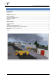
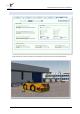
INFORMATION FOR MAASTRICHT - AACHEN AIRPORT
Country: The Netherlands
City: Maastricht
ICAO ID: EHBK
IATA ID: MST
Time: UTC+1(+2DT)
50°54′57″N 005°46′37″E
Elevation: 375 feet (114 meters) (note that things do not go much higher in the Netherlands!)
Type: Civil
RADIO COMMUNICATION FREQUENCIES
Beek Tower 119.475 MHz
Beek Delivery 121.825 MHz
Approach 123.975 MHz
ATIS 124.575
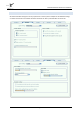
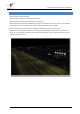
RUNWAYS
Runway 03
Surface ASP: Asphalt,
Heading 032.62°
Latitude 50° 54' 06.61" N
Longitude 005° 45' 36.18" E
Elevation (ft) 365.0
Slope 0.0°
Landing Distance 8202 feet
Takeoff Distance 8202 feet
CL - Centerline Lighting System
HIRL - High Intensity Runway Lights
REIL - Runway End Identifier Lights
PAPI - Precision Approach Path Indicator
Runway 21
Surface ASP: Asphalt
Heading 216.63°
Latitude 50° 55' 14.79" N
Longitude 005° 46' 45.22" E
Elevation (ft) 364.0
Slope 0.0°
Landing Distance 8202 feet
Takeoff Distance 9022 feet
HIRL - High Intensity Runway Lights
REIL - Runway End Identifier Lights
A - ALSF-2
CL - Centerline Lighting System