Aerosoft Maastricht -Aachen X
Aerosoft Maastricht-Aachen X 1.01 Manual CONTENTS INTRODUCTION .................................................................................................................................................... 2 COPYRIGHTS ......................................................................................................................................................... 2 CREDITS ..........................................................................................................................
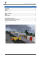
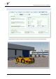
Aerosoft Maastricht-Aachen X 1.01 Manual INTRODUCTION Maastricht Aachen airport has its roots in the Second World War when the US Engineer Corps created Advanced Landing Ground Y-44 as a front line airport for fighter bombers and recce aircraft. Directly after the war is was still busy as the road network of the Netherlands was severely damaged. But when car travel became easier it was decided to keep the airport open and to turn it into a regional airport.
Aerosoft Maastricht-Aachen X 1.
Aerosoft Maastricht-Aachen X 1.01 Manual FINDING THE AIRPORT You will find the airport using either the airport name (Maastricht Aachen), the city name (Maastricht) or the airport ID (EHBK). CHARTS We have added the most current charts for this airport to this manual as Appendix B. Please note you can always find them at http://www.ais-netherlands.nl/aim/111201-120112/eAIP/html/index-en-GB.html.
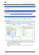
Aerosoft Maastricht-Aachen X 1.01 Manual SCENERY SETTINGS Mesh is important for this scenery. Set Mesh Complexity to 100 and Mesh resolution to 5 meter. Settings below 5 meters will cause problems. Texture resolution should be at 15 cm or less to get the best resolution of the textures. Special effects details should be on High to see all the special animations. For best results we recommend to set Autogen Density to Normal.
Aerosoft Maastricht-Aachen X 1.01 Manual TRAFFIC Traffic settings as shown are advised. This will make the project look best and will avoid problems.
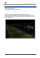
Aerosoft Maastricht-Aachen X 1.01 Manual AIRCRAFT AND WEATHER SETTINGS Aircraft and weather settings are not very important for a scenery but for completion we added the settings our testers found to be most suitable. Note that 3d clouds can have a profound effect on frame rate.
Aerosoft Maastricht-Aachen X 1.01 Manual INFORMATION FOR MAASTRICHT - AACHEN AIRPORT Country: The Netherlands City: Maastricht ICAO ID: EHBK IATA ID: MST Time: UTC+1(+2DT) 50°54′57″N 005°46′37″E Elevation: 375 feet (114 meters) (note that things do not go much higher in the Netherlands!) Type: Civil RADIO COMMUNICATION FREQUENCIES Beek Tower 119.475 MHz Beek Delivery 121.825 MHz Approach 123.975 MHz ATIS 124.
Aerosoft Maastricht-Aachen X 1.01 Manual F.A.QS. Q: Is this add-on DX10 compatible? A: No, the high resolution textures will cause problems. Q: Is this add-on compatible with other add-ons in the area? A: We have tested this with the NL2000 project and found no problems. Do note the we use a color adjusted aerial image that has a more muted color then the rather vivid images used by NL2000. Q: There seem to be issues with the airport lighting at day/night transitions.
MAASTRICHT AACHEN AIRPORT AERODROME CHART AIP NETHERLANDS INSETS SCALE 1 : 7 500 CAUTION: DO NOT CROSS THE HOLDING POSITION MARKINGS WITHOUT A CLEARANCE. 02 JUL 09 AD ELEV 375 ft AMSL ANNUAL RATE OF CHANGE 6’ E W1 W 1 W 1A PRECISION APPROACH LIGHTING SYSTEM CAT I/II/III VAR 1° W (2005) HOTSPOT AD 2.EHBK-ADC A E1 E1 E1 See Note 1 BEEK / BKN & BKZ (111.55) / CH.52 Y 50°55’21’’N 005°46’47’’E W LOC BKZ 111.550 GP 332.
005°46’06’’ 005°46’00’’E AD 2.
MAASTRICHT AACHEN INSTRUMENT APPROACH CHART AIP NETHERLANDS 123.975 Beek Approach 128.350 Dutch MIL outside OPR HR TWR 119.475 Beek Tower 119.700 Reg. Guard ATIS 124.575 Maastricht Information 121.500 General Emergency GP LOC DME 332.750 111.550 BKZ CH.52Y BKZ Notice the short distance between the IF and the FAF available for LOC-course interception. NOTES: Navigation in the initial and intermediate approach segment is primarily based on rader vectors provided by ATC. Given speeds are mandatory.
AIP NETHERLANDS APP (TAR) 123.975 BAXIM 1A, BOBMO 1A, MODRU 1A, OLNO 1A, OSGOS 1A and RUMER 2A TRANSITIONS ILS CAT I / DME MAASTRICHT AACHEN RNAV INSTRUMENT APPROACH CHART RWY 03 FROM RUMER (IAF) Beek Approach 119.475 Beek Tower 119.700 Reg. Guard ATIS 124.575 Maastricht Information 121.500 General Emergency GP LOC DME 332.750 111.550 BKZ CH.52Y BKZ ATC may deviate from the transitions by radar vectors. ILS / DME must be available. DME BKZ reads 1.
MAASTRICHT AACHEN INSTRUMENT APPROACH CHART AIP NETHERLANDS 123.975 Beek Approach 128.350 Dutch MIL outside OPR HR 05 MAY 11 NOTES: 119.475 Beek Tower 119.700 Reg. Guard ATIS 124.575 Maastricht Information 121.500 General Emergency in Amsterdam FIR DME 111.550 BKZ or BKN CH.52Y BKZ or BKN Navigation in the initial and intermediate approach segment is primarily based on radar vectors provided by ATC. Given speeds are mandatory. The approach via BEMTI only at ATC discretion (see page EHBK AD 2.
MAASTRICHT AACHEN INSTRUMENT APPROACH CHART AIP NETHERLANDS APP (TAR) 123.975 TWR 119.475 Beek Tower 119.700 Reg. Guard ATIS 124.575 Maastricht Information 121.500 General Emergency GP LOC DME 332.750 111.550 BKN CH.52Y BKN AD 2.EHBK-IAC-21.1 ILS CAT I/II/III/DME GP INOP RWY 21 Beek Approach 28 JUL 11 FI R NOTE: DME BKN situated 0.2 NM in front of THR21. DME BKN reads 0.2 at THR21.
BAXIM 1B, BOBMO 1B, MODRU 1B, OLNO 1B, OSGOS 1B and RUMER 2B TRANSITIONS ILS CAT I/II/III/DME ST. JOSEPH AIP NETHERLANDS APP (TAR) 123.975 MAASTRICHT AACHEN RNAV INSTRUMENT APPROACH CHART RWY 21 FROM RUMER (IAF) Beek Approach 119.475 Beek Tower 119.700 Reg. Guard ATIS 124.575 Maastricht Information 121.500 General Emergency GP LOC DME 332.750 111.550 BKN CH.52Y BKN ATC may deviate from the transitions by radar vectors. ILS / DME must be available. DME BKN situated 0.2 NM in front of THR 21.
MAASTRICHT AACHEN INSTRUMENT APPROACH CHART AIP NETHERLANDS APP (TAR) 123.975 TWR 119.475 Beek Tower 119.700 Reg. Guard ATIS 124.575 Maastricht Information 121.500 General Emergency DME 111.550 BKN or BKZ CH.52Y BKN or BKZ RWY 21 AD 2.EHBK-IAC-21.
© Air Traffic Control the Netherlands 0 SCALE 1:3500 600 200 900 300 METRES SCALE 1: 500 800 900 0 2 TRAFFIC AIRAC AMDT 02/08 CHANGE: New chart.
AD 2.EHBK-SID-03 MAASTRICHT AACHEN RWY 03 STANDARD DEPARTURE CHART - INSTRUMENT AIP NETHERLANDS RUMER 39.1 MAS 356.2 EINDHOVEN NDB EHN - 397 REKKEN 2A NETEX 24.4 MAS 029.1 VEROR 4A 30 51° 20’ N 11 MAR 10 5° M FIR SELS FIR NF IR NG E ERDA BRUS LA 358° AMST AM ST ER DA M FI R PESER 2A NETEX 1A SOPVI 16.8 MAS 352.9 4 OSGOS 12.8 MAS 352.
AD 2.EHBK-SID-21 MAASTRICHT AACHEN RWY 21 STANDARD DEPARTURE CHART - INSTRUMENT AIP NETHERLANDS RUMER 39.1 MAS 356.2 EINDHOVEN NDB EHN - 397 REKKEN 2B NETEX 24.4 MAS 029.1 VEROR 4B 30 51° 20’ N 11 MAR 10 5° M FIR SELS FIR NF IR NG E ERDA BRUS LA 358° AMST AM ST ER DA M FI R PESER 2B NETEX 1B SOPVI 16.8 MAS 352.9 4 OSGOS 12.8 MAS 352.
7° AD 2.EHBK-SID-OVERVIEW MAASTRICHT / AACHEN STANDARD DEPARTURE CHART-INSTRUMENT AIP NETHERLANDS 11 MAR 10 Detailed information concerning ATS-ROUTES and WPTs see ENR 3, 4 and 6. EELDE / EEL 112.4 / CH.71 X 53°09’50’’N 006°40’00’’E EHD 41E FL 055 MSL EHGG L2 13 FIR STE RD EE AM VEROR BREMEN FIR VEROR 18.8 EEL 213.5 32 AM LO ND ON FIR EH521 27.2 EEL 213.
AD 2.EHBK-STAR.1 MAASTRICHT / AACHEN STANDARD ARRIVAL CHART-INSTRUMENT AIP NETHERLANDS 20 DEC 07 Detailed information concerning ATS-ROUTES and WPTs see ENR 3, 4 and 6 EELDE / EEL 112.4 / CH.71 X 53°09’50’’N 006°40’00’’E EHD 41D FL 055 MSL EHD 41A-C FL 480 MSL EHD 41E FL 055 MSL EHGG See EHGG SIDs Gunfiring up to 48000 ft AMSL 181° 32 EE EHLE SCHIPHOL / SPL 108.4 / CH.21 X / ATIS 52°19’56’’N 004°45’00’’E BREMEN FIR AMSTERDAM FIR 21 VEROR 18.8 EEL 213.
SEP 09 RUMER 39.1 MAS 356.2 TENLI 2M RUMER 2M 178° 51° 20’ N P5 7 ERDA M FIR SELS FIR SOPVI 16.8 MAS 352.9 NETEX 1M P57 21 9° BRUS NETEX 24.4 MAS 029.1 AM S TE RD AM LA FIR NG EN F IR EINDHOVEN NDB EHN - 397 Detailed information concerning ATS-ROUTES and WPTs see ENR 3, 4 and 6 AMST AD 2.EHBK-STAR.2 MAASTRICHT AACHEN STANDARD ARRIVAL CHART - INSTRUMENT AIP NETHERLANDS H C BA AD DS L I G S EN NT CH VA N E Ö L M RE OM SEE R F 51° 10’ 173° OSGOS 1M QD M 21 NW 3° OSGOS 12.
MAASTRICHT AACHEN VISUAL APPROACH CHART AIP NETHERLANDS AD 2.EHBK-VAC.
MAASTRICHT AACHEN 614 VFR TRAFFIC CIRCUITS AIP NETHERLANDS AD 2.EHBK-VAC.