
User manual

Aerosoft H36 Dimona X 1.00 Manual
Page 6 of 21
Note: When used in Windows Vista the GPS device cannot be rotated. For some weird reason the
animation will not work. Not a big issue.
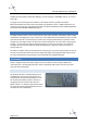
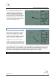
To turn the GPS on, press the button with the
red logo. The following start-up screen
appears:
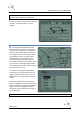
MAP MODE
After initialization the GPS will be in Map
Mode: On the left 2/3 part of the display a
map is drawn, showing the current position
with an aircraft symbol. North is always up.
On the right 1/3 part of the display, current
ground speed, distance to next waypoint,
estimated time to next waypoint and a
pointer depicting relative bearing to the
next waypoint is shown. If the pointer points
up, the aircraft is heading straight towards
the next waypoint. Use the IN / OUT buttons
to zoom the map in or out.
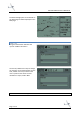
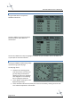
The GPS can show Airports, VOR’s, NDB’s,
Intersections and Airspace boundaries. To
toggle the display of these items press the
MENU button. The Setup page will now be
shown:
Use the UP / DOWN cursor key (the large
button) to highlight the Class (Airport, VORs,
NDBs, Intersection or Airspace). Use the Left
/ Right cursor key to toggle the display of
these items. Use the QUIT button to return
to the MAP page.
Note: the framerate of the simulator is affected by the amount of information shown!