
User manual

Aerosoft Aspen Extended 1.00
Page 10
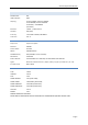
NEARBY RADIO NAVIGATION AIDS
VOR radial/distance VOR name Freq Var
DBLr163/13.0 RED TABLE VOR/DME 113.00 12E
SXWr155/25.0 NOW VOR/DME 109.20 12E
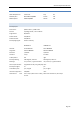
RUNWAY INFORMATION
Runway 15/33
Dimensions: 8,006 x 100 ft. / 2,440 x 30 m
Surface: asphalt/grooved, in fair condition
Single wheel: 80,000 lbs
Double wheel: 100,000 lbs
Double tandem: 160,000 lbs
Runway edge lights: medium intensity
RUNWAY 15 RUNWAY 33
Latitude: 39-13.930557N 39-12.849228N
Longitude: 106-52.388910W 106-51.872882W
Elevation: 7,679.8 ft. 7,819.9 ft.
Gradient: 2.0 up 2.0 down
Traffic pattern: left right
Runway heading: 148 magnetic, 160 true 328 magnetic, 340 true
Markings: non precision, in good condition non precision, in good condition
Visual slope indicator: 4-light PAPI on left (3.5° glide path) none
Runway end lights: no yes
Touchdown point: yes, no lights yes, no lights
Instrument approach: LOC/DME none
Obstructions: none 22 ft. road, 1,100 ft. from runway, 550 ft. left of centerline, 40:1 slope
to clear