
General Guidelines

Aerosoft
Airbus
A318/A319/A320/A321
The Airbus A318/A319/A320/A321 In FSX
General guidelines
Vol
1
01-03-8
21 October 2015
WEATHER RADAR
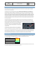
As the weather radar is a totally new development and not in this form in any other project it is good to
discuss its virtues and limitations.
The weather radar in the Aerosoft Airbus products works with any weather add-on or even without. It
actually reads the weather conditions in FSX and does not need to link to any weather add-on. However
because it does just that it also shows some of the limitations of weather in FSX. For example it is always
build up in square blocks. We choose to leave this effect visible because we believe a weather radar should
show where the weather is, not how it should look in an ideal simulator. Because we simulate the actual
working of the weather radar it also means a lot of calculations need to be done, this can have an effect on
your frame rate. Because wind shear and turbulence cannot correctly be placed in FSX detection of that is
currently not possible.
As stated, the weather radar works with any weather add-on we have tried. But only the weather they
inserted in FSX is detected. If they have weather that is shown on their own display but that has not yet
been send to FSX it cannot be shown. As this weather is not in FSX it is of course not part of the simulation
at that moment. In other words, if you can’t see the weather
the weather radar can’t see it. Compatibility with weather
tools that do not adhere to SDK standards is considered but
not guaranteed.
The display of the weather (and terrain) on the Navigation
Display is controlled by the larger part of the ND control knob.
On a few systems the Weather Radar has shown to cause severe drop in frame rates combined with some
advanced settings in weather tools. It is now possible to edit some functions via the AB_ND_GDI.ini (to be
found in MyDocuments\Aerosoft\Airbus. The options are explained in the comments in that file.
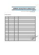
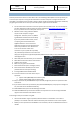
TERRAIN DISPLAY
Just as the Weather Radar the Terrain Display is an overlay on the Navigation Display. The terrain is shown
in colors depending on the height of the terrain in relation to the altitude of the aircraft.
A/C Altitude +2000
50% Red
A/C Altitude + 1000
50% Yellow
A/C Altitude -250 <> +500
25% Yellow
A/C Altitude -1000
50% green
A/C Altitude -2000
16% Green
A/C Altitude >2000
Black
Note that the terrain and weather cannot be displayed at the same time and that the same control it used
as the weather display to set the transparency of the overlay.