
Step by Step Guide

A318/319/320/321
Profesional
Step-By-Step Tutorial
Vol
6
06-01- 12
11. Dezember 2018
MODE
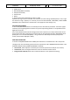
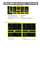
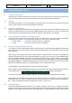
Turbulence is displayed in magenta out to maximal 40 nautical miles for all selected ranges (as in real
aircraft). No detecting of clear-air turbulence as only areas of precipitation are evaluated.
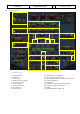
WX: Normal WX Radar as it was implemented so far (precipitation targets).
WX+T: Precipitation targets with turbulence information overlaid.
TURB: Only turbulence information without precipitation targets.
MAP: Enables display of all radar echoes including terrain and precipitation information, but the
receiver sensitivity for precipitation returns is decreased so that terrain characteristics are
pointed out. No turbulence information is displayed.
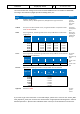
ND – Navigation Display (Turbulences -magenta - )
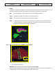
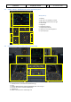
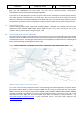
2.1.4. ND – Navigation Display (EGPWS - Terrain on ND)
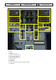
ND – Navigation Display (Takeoff at LOWI 08)
1 = Lowest and highest elevation
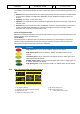
EGPWS (Enhanced Ground Proximity Warning System) terrain picture
The ND displays the EGPWS terrain picture, when TERR ON ND switch is selected ON and the ND is not
in PLAN mode. The terrain picture replaces the weather radar image.
1