
User's Manual

SYSTEM DESCRIPTION AND INSTALLATION MANUAL
T
3
CAS/Part No.9005000
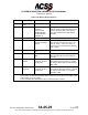
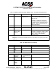
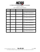
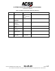
Table 1-29: BDS 0,6 Surface Position
Bits
Parameter
Parameter Data
External Source(s)
1-5
Format Type
Code
0, 5-8
See NOTE:
6-12
Movement
NO INFO
STOPPED
Speed in Knots
DECELERATING
ACCELERATING
BACKING UP
Label 112 Ground Speed from GPS 1 or 2
(best HIL value) or else Label 312 Ground
Speed from IRS or FMS or else derived
from Label 174 E/W and Label 166 N/S
velocities.
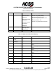
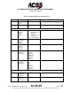
13
Status Heading
14-20
Heading
N/A
Decoded Heading in
degrees.
Label 314 True Heading from IRS or else
Label 103 Ground Track from GPS 1 or 2
(best HIL value) - only if GS > 20 kts or
Label 313 True Track Angle from IRS only
if GS > 20 kts.
21
Time
N/UTC (Not UTC)
UTC
22
CPR Format
EVEN
ODD
Label 150 UTC Coarse, Label 140 UTC
Fine, and Label 141 UTC Fine Fraction
from GPS
23-39
Encoded
Latitude
Decoded CPR format
in degrees, minutes
and seconds.
Label 110 Latitude (coarse) and Label
120 Latitude (fine) from GPS 1 or 2 (best
HIL value) or else Label 310 Latitude from
FMS or IRS.
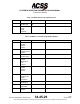
40-56
Encode
Longitude
Decoded CPR format
in degrees, minutes
and seconds.
Label 111 Longitude (coarse) and Label
121 Longitude (fine) from GPS 1 or 2 (best
HIL value) or else Label 311 Longitude
from FMS or IRS.
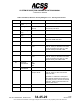
NOTE:
Label 130 HIL from GPS or Label 171 RNP from FMS or IRS,
or else Label 112 Ground Speed from GPS or Label 312 Ground Speed from FMS or IRS,
or else Label 133 VIL from GPS,
or else Label 203 Baro Altitude from ADC or label 370 HAE from GPS.
Pub. No. 8600200-001, Revision 004
34-45-29
1-124
04 Nov 2014
Use or disclosure of information on this page is subject to the restrictions in the proprietary notice of this document.