
User's Manual

SYSTEM DESCRIPTION AND INSTALLATION MANUAL
T
3
CAS/Part No.9005000
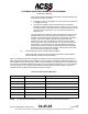
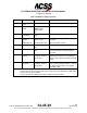
Table 1-28: BDS 0,5 Airborne Position
Bits
Parameter
Parameter Data
External Source(s)
1-5
Format Type
Code
0, 9-18, 20-22
See NOTE:
6-7
Surveillance
Status
NO INFO
PERM ALERT
TEMP ALERT
SPI
Label 016 from ATC/TCAS control panel.
8
Single Antenna
Flag (SAF)
SINGLE
DUAL
9-20
Barometric
altitude
or
GNSS Altitude
Decoded Barometric
Altitude in feet
Decoded HAE in feet.
Label 203 uncorrected pressure altitude
from ADC.
Label 370 HAE from GPS
21
Time
N/UTC (Not UTC)
UTC
Time mark from GPS.
22
CPR Format
EVEN
ODD
Label 150 UTC Coarse, Label 140 UTC
Fine, and Label 141 UTC Fine Fraction
from GPS
23-39
Encoded
Latitude
Decoded CPR format
in degrees, minutes
and seconds
Label 110 Latitude (coarse) and Label 120
Latitude (fine) from GPS 1 or 2 (Best HIL
value) or else Label 310 Latitude from FMS
or IRS
40-46
Encoded
Longitude
Decoded CPR format
in degrees, minutes
and seconds
Label 111 Longitude (coarse) and Label
121 Longitude (fine) from GPS 1 or 2 (best
HIL value) or else Label 311 Longitude
from FMS or IRS
NOTE:
Label 130 HIL from GPS or Label 171 RNP from FMS or IRS,
or else Label 112 Ground Speed from GPS or Label 312 Ground Speed from FMS or IRS,
or else Label 133 VIL from GPS,
or else Label 203 Baro Altitude from ADC or label 370 HAE from GPS.
Pub. No. 8600200-001, Revision 004
34-45-29
1-123
04 Nov 2014
Use or disclosure of information on this page is subject to the restrictions in the proprietary notice of this document.