
User's Manual

SYSTEM DESCRIPTION AND INSTALLATION MANUAL
T
3
CAS/Part No.9005000
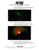
Figure 1-26: Terrain Display Background
(b) Terrain Advisory Line
The Terrain Hazard Display can also depict a Terrain Advisory Line. The
Terrain Advisory Line is drawn at the points where a CPA caution will
occur if the aircraft continues along its current vertical trajectory. When
there are no CPA cautions or warnings active, T
3
CAS TAWS will
determine if a Terrain Advisory Line needs to be drawn. Beginning at the
current aircraft position, T
3
CAS TAWS looks ahead of the aircraft to
determine where a CPA caution will occur. T
3
CAS TAWS will monitor
terrain up to 120 seconds ahead of the current position. If T
3
CAS detects
that the aircraft is within 15 nautical miles of a mountainous airport, the
prediction distance of the TAL will be progressively reduced from 120
seconds down to 30 seconds at 5 nautical miles.
For the purposes of the Terrain Advisory Line, when the absolute value
of the Roll Angle is within 5 degrees, the aircraft is considered to be in
“wings level” flight. Under this wings level flight condition, the TAL is only
calculated using an extraction aperture of 1.5 degrees on either side of
the aircraft’s current track projection. This will result in a single Terrain
Advisory Line and an alert if the aircraft’s current trajectory is maintained.
When the absolute value of the Roll Angle is greater than 5 degrees,
TAL calculation is opened up in the direction of the turn at an angle equal
to 90 degrees. The TAL extraction is extended along the flight path angle
to the full prediction distance of 30-120 seconds based off of the distance
to nearest airport and mountainous area airports consideration. The side
opposite of the turn remains at an extraction aperture of 1.5 degrees. If
any CPA cautions would be triggered in this area, the Terrain Advisory
Line will be drawn on the terrain hazard display.
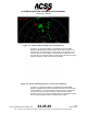
Figure 1-27 illustrates the Terrain Advisory Line. The Terrain advisory
line is the solid yellow line located at about the 5-nautical mile range ring.
As the aircraft continues, this line (as well as the background terrain)
would get closer to the aircraft symbol. When the Terrain Advisory Line
reached the aircraft symbol, a CPA caution would occur. Thus the
Pub. No. 8600200-001, Revision 004
34-45-29
1-96
04 Nov 2014
Use or disclosure of information on this page is subject to the restrictions in the proprietary notice of this document.