
Instruction manual


PROFICIENCY IN SURVIVAL CRAFT AND RESCUE BOATS OTHER THAN
FAST RESCUE BOATS
14 12
Depending on the satellite geometry and the ship's drift the position error goes
down to 1 to 50 NM.
With COSPAS/SARSAT 406-MHz EPIRBs the amount of false alarms
could be reduced dramatically but is still quite high. The major disadvantege
of LEO satellites is the dependency of satellites in the low earth orbit. The
disabled vessel has to wait for the satellite to pass by. Depending on the
lattitude this may take hours. And a delay of 15 minutes to 4 hours may apply.
COSPAS/SARSAT EPIRBs like the navtec global-C plus EPIRB can be fitted
with GPS-receivers. This improves the position estimation to an accurate
position indication. GPS fitted COSPAS/SARSAT EPIRBs like the navtec
global-C plus EPIRB can operate via geostationary satellites (GEOSAR) when
available and when the geometry allows for reaching the satellite.
How will a 406MHz distress beacon help save your life?
• It works. Only 406MHz distress beacons are monitored by satellite.
• It’s faster. Once activated, the signal from a 406MHz distress beacon
is picked up almost instantly by satellite. The satellites supporting the old
121.5MHz and 243MHz distress beacons have been deactivated and can can
no longer determine your location - this could cost you your life.
• It’s more Accurate. 406MHz distress beacons give rescuers a search
area of approximately 20 square kilometres. However, we strongly
recommend GPS equipped EPIRB’s as they reduce the search area down to
only a few square metres. This takes the ‘search’ out of search and rescue,
and increases your chances of survival. Any 406MHz beacon is a huge
improvement on the old 121.5/243MHz beacons.
• It brings the right response. With 406MHz distress beacons, alerts
are cross-referenced against a database of registered owners. Having this
information improves rescuers’ ability to help you in an emergency, and to
respond appropriately. Being able to contact you (or a person you nominate)
also saves time and resources from being wasted on false alerts – out of the
1300 121.5MHz activations in the last two years, only 9% were for a real
emergency.
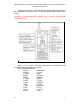
The COSPAS-SARSAT system provides distress alert and location
information to search and rescue authorities anywhere in the world for
maritime, aviation and terrestrial users in distress.
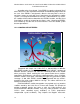
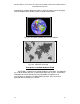
There are two satellite arrays carrying the COSPAS-SARSAT system. The
principal array is LEOSAR (Low Earth Orbit Search and Rescue) which has
seven satellites in polar and near-polar orbits. The orbits of these satellites
are arranged to scan the entire surface of the Earth; on average, a satellite
comes into view every 45 minutes.
Distress transmissions from EPIRBs are picked up by the satellites and
retransmitted to ground receiving stations, which then pass the message to
the appropriate rescue organisation. On average, the total delay from
activation of an EPIRB to the message being received by the rescue services
is 90 minutes.
COSPAS-SARSAT is in an advanced stage of commissioning the second
satellite array, GEOSAR (Geostationary Search and Rescue). This array uses