
User Guide

Y1-03-0148 Rev. F
11
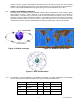
location to within 110 yards. This speeds up the reaction time by not having to wait for one of the LEOSAR
satellite to pass overhead. Because most of the search and rescue forces presently are not equipped to
home in on the 406 MHz Satellite beacons signal, homing must be accomplished at 121.5 MHz.
6.3 GLOBAL POSITIONING SYSTEM (GPS)
The GPS system is a satellite group that enables a GPS receiver to determine its exact position to within
30m anywhere on Earth. With a minimum of 24 GPS satellites orbiting the Earth at an altitude of
approximately 11,000 miles they provide users with accurate information on position, velocity, and time
anywhere in the world and in all weather conditions. The RapidFix™ 406 stores this data into its distress
transmission allowing search and rescue forces to narrow the search into a very small area and thus
minimize the resources required and dramatically increases the effectiveness of the overall operation.
6.3.1 The Satellite
2
™ 406 and RapidFix™ 406 EPIRB are available in multiple combinations. The following
product codes define the options available to meet specific operational requirements:
Prod. No. Model No. Cat. 1 Cat. 2 GPS Interface
2774 RLB-32 X
2775 RLB-32 X
2776 RLB-33 X X
2777 RLB-33 X X
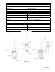
Figure 9- Satellite coverage Figure 10- GEOSAR satellite orbits
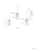
Figure 11- GPS satellite orbits