
User Guide

User Manual 43 Y1-03-0203 Rev. J
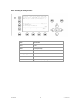
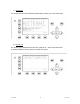
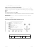
b) Own Ship Data
This screen shows own Ship, and Voyage Data, which was previously input in Menu 3: Ship Settings
and Menu 4: Voyage Settings.
Own Vessel Position:
LAT :S 74-50'23" LON :W 9-34'19"
Heading and Rotation of own vessel:
Heading :77
o
ROT :-0.2
o
/min l
IMO-Number and MMSI of own vessel:
IMO No. : 9100254 MMSI: 257530700
Name and CallSign of own vessel:
ShipName: MYLADY CS: D11233
Vessel Type:
Pilot vessel
Length and Beam of own vessel:
Length:310m Beam:73m
Reference Point (in meters):
This information indicates the Reference Point of the used GPS Antenna onboard the vessel.
RefPoint:A190 B120 C10 D>63m
A: 190m
B: 120m
C: 10m
D: >63m (means more than 63m in the case of a very large ship)
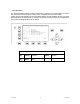
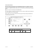
N 1
o
26' E 0
o
19' |1>0.10|2>1.30|3>1.80nm
Time 0:08 ------------------------------
LAT :N 1
o
18.901'LON :E 0
o
12.345'
Heading :222
o
ROT :+5.4
o
/min r
IMO No. :9100254 MMSI:257530700
ShipName:MYLADY CS:D11233
ShipType:Pilot vessel
Length :220m Beam:43m
RefPoint:A190 B30 C20 D23m
Cargo :N/A or harmless
Draught :24.8m
Dest. :CASABLANCA
ETA :10/13 12:31
NavStat.:Engaged in fishing
EPFDType:Integrated navigation system
PosAcc :Low >10m DTE :Available