
User Guide


User Manual 58 Y1-03-0211 Rev. B
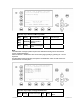
Example:
Length (of the complete convoy) = 400m
Beam (of the complete convoy) = 32m
Internal GPS-Antenna is mounted 20 metres from stern and 24 metres from starboard.
Length(Conv) : 400
Beam(Conv) : 32
RefPtExt :
RefPtInt : B20D24 (!! without spaces, no decimals, no commas !!)
The full line as shown will be displayed after pressing Enter:
RefPtInt : A380 B20 C8 D24m
(A and C are calculated by the AIS).
Enter RefPtExt (location of the external GPS antenna) in the same way.
Note:
The field ATIS Code will be shown as Call Sign in “High Seas” - Mode.
The field Length(ship) and Beam(Ship) are only the values of the ship and calculated in dm
(1m / 10).
Save the new settings by pressing [Save]. Press [Back] return to the Main Menu Screen
without saving any changes.
Dynamic Keys: Input of Ship Settings
[M5] [Save] Confirm Data Input [M8] [Back]
Return to Main
Menu
N 1^19' E 0^12' |1>0.01|
2
>1.30|3>1.80nm
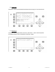
************ Ship Settings *************
Atis Code :max. 7ASCII +------+
ShipName :NAUTICAST | |
Length(Conv):400m | A
Beam(Conv) :32m | |
RefPtExt :A380 B20 C8 D24m | x--|
RefPtInt :A380 B20 C8 D24m | | B
Length(ship):600dm | | |
Beam(ship) :220dm +-C-+D-
+
----------------------------------------
| Save | | | Back