
User Guide


j) Water Level Message
This message is sent by base stations to give water level information to all vessels in a certain
area. The AIS can show up to 120 message entries. Messages are sorted by country code and
gauge ID, which is the unique identification of the measuring point. Information from same gauge
will be overwritten by the latest message. Water levels older than 1 hour will be deleted
automatically.
Dynamic Keys: Broadcast Message Editor
[M8]
[Back]
Return to Messages
Menu
3.5.2 AIS Status
a) State / Conditions
This screen provides a means to viewing the current AIS status of all vessels within receiving
(Time), the Transponder mode (Mod.), the synchronization status (Syn.) and the total number of
vessels being received by each vessel in the listing (RXVe)(MMSI) number is also
shown on the right hand side of the screen.
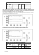
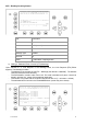
N 1
o
22' E 0
o
15' |1>0.10|2>1.30|3>1.80nm
********** State / Conditions ***** AIS1
ShipName......Time.Mod.Syn.RXVe..MMSI...
DOREEN 2:07 AU I 1 5004
FINE EAGLE 4:51 AU I 11 5008
SYLVAEPSILON 2:54 AU I 1 5264
ESSOTOKYO 2:11 AU D 2 5776
OLYMPIAHIGHWA 6:44 ?? D 1 354503000
SANEI 5:39 AU I 6 776840000
KATOO 2:58 AU D 3 203375830
OLYMPIA PALAC 6:01 AS D 2 241455470
MINILOG 4:42 AS D 7 234712450
ALIBRAHIMYA 7:40 AS B 3 232834560
TITANIC 0:57 AS I 2 419245790>
----------------------------------------
| | | | Back
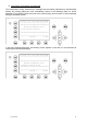
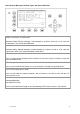
N48^12' E 16^26' |1> N/A|2>0.00|3>0.00nm
********* Water level messages *********
Page: 1 of 1
YY-MM-DD hh:mm Ctry Gauge Level
10-05-14 12:09 AT 0006 321 cm
10-05-14 12:09 AT 0007 370 cm
10-05-14 12:09 AT 0008 334 cm
10-05-14 12:09 AT 0009 321 cm
----------------------------------------
| | | |<-Back
Y1-03-0211G
39