
User manual


GlobalWatch™ UAIS User Manual 39 Version 1.0
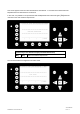
Sample:
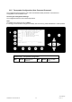
Display:
CallSign = D11233
ShipName = M/V TUGELA
Length = 20m
Beam = 30m
RefPointExt = A170 B30 C15 D15m (location of the external GPS antenna)
RefPointInT = A170 B30 C9 D11m (location of the internal GPS antenna)
ShipType = Tug
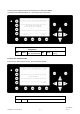
With the up/down keys you may move from line to line and input the correct data. The last line “ShipType:“
must be selected by actuating the left/right keys out of the pool of all possible types. Actuate “Enter”
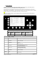
Special is the setting of the GPS antenna position:
The first settings which have to be entered are Length and Beam of the ship in meters.
Next step: enter 2 values more per location to specify the distance from the bow and from the side.
Distances are to be set in meters.
A = the distance from bow to the antenna
B= the distance from the antenna to the stern
C = the distance from the port side to the antenna
D = the distance from the antenna to the starboard side
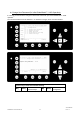
Example: Length =200m, A = 160m, Beam = 30m, D = 15m
Move with Up/down keys to the Length line. Type 200, actuate “Enter”
Move one line down. Type 30, actuate “Enter”
RefPtExt and RefPtInt both show “N/A” now.
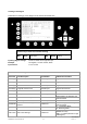
Only one of the length values A or B must be entered and one of the width values C or D.
For our example in the RefPtExt – line type as follows:
A160D15 (without spaces)
Actuate “Enter”
The full line as shown will be displayed: RefPtExt: A160 B40 C15 D15m
B and C are calculated by the AIS.
Do the same with the RefPtInt – line
Actuate soft key “Save”
Display: Data Saved
Y1-03-0178A