
User manual


GlobalWatch™ UAIS User Manual 38 Version 1.0
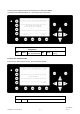
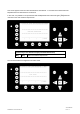
After the Ship Settings have been input and saved, this screen appears.
[Exit] takes the user back to the Main Menu.
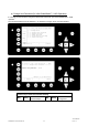
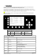
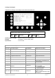
GPS Antenna Mounting
It is important to input the exact mounting position of the GPS Antenna on the vessel as this influences the
accuracy of the displayed target in an ECDIS.
(RefPntExt:) = The position of any external positioning device (GPS Antenna) used as primary position
source.
(RefPntInt:) = The position of the GPS Antenna (fallback device in case primary source is disabled).
After antenna installation, the distance from the sides must be measured and input.
Either the distance from the vessel’s bow (a) or the stern (b) and starboard (d) and backboard (c) are
required.
e.g. A vessel with the following dimensions:
Length: 100m
Beam: 20m
Input: A90C5 - then press Enter or
B10D15 - then press Enter
Result:
RefPtExt: A90 B10 C5 D15m
The GlobalWatch™ UAIS automatically calculates the missing distances (a) or (b) and (c) or (d) - based on
the vessel’s length and beam.
Note:
When receiving position data from large vessels, it should be considered that the position refers to the
antenna mounting point upon the vessel. To ensure accurate navigation, the antenna reference points (see
Other Vessels Details) should be taken into consideration when determining the vessels position.
Also, the electronic chart display in use should be programmed to consider the antenna reference points.
Traffic images are represented in true distances only when all displayed targets, including own vessel, are
working with AIS position information, which considers Antenna reference points.
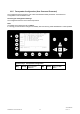
N 1^30' E 0^24' |1>0.10|2>1.30|3>1.80nm
----------------------------------------
++++++++++++++++++++++++++++++++++++++++
Data saved.
++++++++++++++++++++++++++++++++++++++++
----------------------------------------
| | | | <-Exit
Y1-03-0178A